Updating search results...

Search Resources

37 Results

View
Selected filters:
  • interactive
Next-Generation Molecular Workbench
Conditional Remix & Share Permitted
CC BY-NC
Rating
0.0 stars

Molecular Workbench (MW) is powerful, award-winning software that provides visual, interactive computational experiments for teaching and learning science. These simulations are HTML5 and work well on non-java based platforms.

Subject:
Biology
Chemistry
Life Science
Physical Science
Physics
Material Type:
Activity/Lab
Simulation
Author:
MIT or Apache 2.0 licenses.
This project is © Copyright 2017 by The Concord Consortium and is distributed under the Simplified BSD
Date Added:
11/14/2018
PFAS Interactive Data Viewer - Wisconsin Department of Natural Resources
Only Sharing Permitted
CC BY-NC-ND
Rating
0.0 stars

The PFAS Interactive Data Viewer is a mapping tool that incorporates datasets from several DNR programs to show locations throughout Wisconsin that have been impacted by PFAS.

Information included in the PFAS Interactive Data Viewer include locations with known PFAS contamination and whether clean up has been completed; results from testing municipal drinking water for PFAS; locations with PFAS-related fish and game consumption advisories; and waterbodies throughout Wisconsin sampled for PFAS during targeted or routine monitoring.

These data may not reflect current PFAS levels at specific locations.

Subject:
Agriculture, Food and Natural Resources
Anatomy/Physiology
Biology
Career and Technical Education
Chemistry
Civics and Government
Earth and Space Science
Ecology
Environmental Science
Family and Consumer Sciences
Forestry and Agriculture
Geology
Health Science
Hydrology
Life Science
Marketing, Management and Entrepreneurship
Physical Science
Social Studies
Technology and Engineering
Material Type:
Data Set
Diagram/Illustration
Interactive
Author:
Wisconsin Department of Natural Resources
Date Added:
03/12/2024
Português para principiantes – Open Textbook
Conditional Remix & Share Permitted
CC BY-NC-SA
Rating
0.0 stars

This is an interactive open textbook that features a number of activities and audio clips for learners to use as they anchor language materials. In addition to being a great resource for learning Portuguese, it provides useful examples of ways to use H5P activities to increase formative assessment opportunities for students.

Subject:
World Languages
Material Type:
Interactive
Textbook
Author:
Department Of Spanish Portuguese Uw-madison
Date Added:
03/29/2019
Protecting Wisconsin's Biodiversity
Conditional Remix & Share Permitted
CC BY-NC
Rating
0.0 stars

Biodiversity is a shortened form of the term "biological diversity." The entire spectrum of life forms and the many ecological processes support them. Wisconsin is blessed with abundant biodiversity. Located at the junction of the eastern deciduous forest, northern boreal forest and temperate grasslands, we have a wealth of species and natural communities.

Approximately 1,800 species of native plants and close to 700 species of native vertebrates have been identified in Wisconsin. In addition, there are thousands of species of non-vascular plants and invertebrates. These pages highlight the uncommon and rare species, natural communities, geological features and essential habitat areas throughout Wisconsin.

Subject:
Agriculture, Food and Natural Resources
Biology
Botany
Career and Technical Education
Early Learning
Ecology
Education
Elementary Education
Environmental Science
Forestry and Agriculture
Health Science
Life Science
Zoology
Material Type:
Activity/Lab
Data Set
Interactive
Author:
Wisconsin Department of Natural Resources
Date Added:
04/21/2024
Selma
Rating
0.0 stars

This website is interactive, allowing students to work through 7 different "chapters" that detail the events leading up to, during and impact of the March on Selma. It includes primary source video clips, photographs, quotations, and clips from the movie, "Selma". Students can do one, or multiple of the chapters, or the site could be used as a jigsaw with different groups. Includes teacher's guide.

Subject:
Civics and Government
Ethnic Studies
Social Studies
U.S. History
Material Type:
Activity/Lab
Homework/Assignment
Interactive
Author:
Hutchins Center for African American Research at Harvard University
Southern Poverty Law Center
Teaching Tolerance
Date Added:
08/05/2023
Sesame Workshop - Autism
Rating
0.0 stars

Learn what Autism is and how to see the amazing in all children! Celebrate and support kids with autism and every child. Every child experiences the world differently, including kids with autism. Abby explains that, even though all of her friends are different, they all want love, friendship, and to have fun!

Subject:
Early Learning
Education
Elementary Education
School Counseling
Special Education
Material Type:
Activity/Lab
Game
Interactive
Lesson
Author:
Sesame
Sesame Workshop
Date Added:
07/22/2023
Snapshot Wisconsin Data Dashboard
Conditional Remix & Share Permitted
CC BY-NC
Rating
0.0 stars

Snapshot Wisconsin is a partnership to monitor wildlife year-round, using a statewide network of trail cameras. Snapshot Wisconsin provides data needed for decision making at the Wisconsin Department of Natural Resources. It is also a unique opportunity for individuals, families, and students to get involved in monitoring the state’s valuable natural resources. This tool is designed to help visualize many aspects of Snapshot Wisconsin data.

Subject:
Agriculture, Food and Natural Resources
Art and Design
Biology
Career and Technical Education
Ecology
Environmental Science
Fine Arts
Forestry and Agriculture
Genetics
Life Science
Marketing, Management and Entrepreneurship
Zoology
Material Type:
Data Set
Interactive
Other
Reference Material
Author:
SnapShot Wisconsin
Wildlife Restoration
Wisconsin Department of Natural Resources
Date Added:
04/21/2024
Supreme Court: Classroom Interactive
Unrestricted Use
Public Domain
Rating
0.0 stars

Think that the Supreme Court doesn't apply to your day-to-day life? Think again!The decisions the Court makes today, as well as its decisions in the past, have a real and lasting impact on the way Americans live their lives.This activity describes 10 situations encountered in the daily life of an American teen. Take a look at each scenario, and then choose the related Supreme Court decision that directly impacts our rights and freedoms as citizens of the United States.

Subject:
Civics and Government
Social Studies
Material Type:
Game
Interactive
Learning Task
Provider:
Educational Broadcasting Corporation
Date Added:
03/08/2017
Supreme Court: Timeline Interactive
Restricted Use
Copyright Restricted
Rating
0.0 stars

Throughout US history, the Supreme Court´s rulings have had a real and lasting effect on the everyday lives of Americans.  In this activity, you will be sorting these landmark cases into the correct decades in which they were decided.  When you have them all correct, you can click on the cards to get more information on each case.

Subject:
Civics and Government
Social Studies
Material Type:
Interactive
Learning Task
Lesson Plan
Self Assessment
Provider:
Educational Broadcasting Corporation
Date Added:
03/08/2017
A Table for 22: A Real-World Geometry Project (area and perimeter)
Unrestricted Use
CC BY
Rating
0.0 stars

In this lesson, students deepen their understanding of the measurement of plane and solid shapes and use this understanding to solve problems. Students also identify and describe the properties of two-dimensional figures. Students are challenged to set a table for 22 using one unit lengths of paper (each unit length represents one student sitting at the table). They are asked to pretend that they all want to sit together for a dinner, and the table has to be rectangular. They must figure out what the table will look like if it must be rectangular and if everybody must sit at the table. They must determine what's the biggest table going to look like where everybody sits, and what's the smallest table going to look like where everybody sits. Students work to conceptually figure out relationships between perimeter and area in a creative and interactive way. They brainstorm ideas in groups, discuss as a class to determine the best options, and then physically set the two tables using strips of paper that represent "one unit" in length per person.

Subject:
Mathematics
Material Type:
Learning Task
Lesson Plan
Simulation
Provider:
Teaching Channel
Date Added:
12/28/2015
Teaching Sortify: U.S. Citizenship
Rating
0.0 stars

Website Description:
Are your students experts on U.S. citizenship? Put their knowledge to the test with Sortify: U.S. Citizenship, an original BrainPOP game made by BrainPOP with iCivics.
Share Sortify: U.S. Citizenship with your students using the “Share” button above. You must be logged in to access. This new feature allows teachers to assign Sortify outside of iCivics using learning management systems like Google Classroom, Edmodo, and more.

Student Learning Objectives:
Students will be able to...
*Recognize and recall rights and responsibilities of U.S. citizens
*Identify active ways in which citizens can participate in government and contribute to the common good
*Relate like terms and concepts by deducing shared relationships

Subject:
Social Studies
U.S. History
Material Type:
Activity/Lab
Learning Task
Lesson Plan
Author:
iCivics
Date Added:
06/14/2023
Water Resources of the United States—National Water Information System (NWIS) Mapper - USGS
Only Sharing Permitted
CC BY-NC-ND
Rating
0.0 stars

The National Water Information System (NWIS) Mapper provides access to over 1.5 million sites contained in the USGS National Water Information System (NWIS), including sites where current and historical surface-water, groundwater, springs, and atmospheric data has been collected. Users can search by site type, data type, site number, or place.

Subject:
Agriculture, Food and Natural Resources
Atmospheric Science
Business and Information Technology
Career and Technical Education
Earth and Space Science
Ecology
Education
Elementary Education
English Language Arts
Environmental Literacy and Sustainability
Environmental Science
Forestry and Agriculture
Geography
Geology
Health Education
Health Science
Higher Education
Hydrology
Life Science
Literature
Marketing, Management and Entrepreneurship
Oceanography
Social Studies
Technology and Engineering
Material Type:
Activity/Lab
Homework/Assignment
Author:
USGS (US Geological Survey)
Date Added:
03/12/2024
Wisconsin DNR Open Data Portal
Only Sharing Permitted
CC BY-NC-ND
Rating
0.0 stars

This is the Wisconsin Department of Natural Resources GIS Open Data Portal. It is a free resource for locating, viewing, and downloading data developed and/or maintained by the Wisconsin DNR.

This site also has categories of: Water, Fish and Wildlife, Managed Lands, Cimate, Parks and Recreation, Forestry, Transportation, Indexess and PLSS, Boundaries and Land Cover and Vegetation.

The site also has Applications that include: PFAS in Wisconsin Data Viewer, Western Coulee and Ridges Regional Master Plan, North Central Forest Regional Master Plan, Wildfires Dashboard App, Report Invasive Species, CWD reporting, etc

Subject:
Agriculture, Food and Natural Resources
Biology
Botany
Career and Technical Education
Civics and Government
Earth and Space Science
Ecology
Education
Elementary Education
Environmental Literacy and Sustainability
Environmental Science
Forestry and Agriculture
Geography
Geology
Health Education
Health Science
Higher Education
Hydrology
Life Science
Social Studies
Zoology
Material Type:
Activity/Lab
Homework/Assignment
Learning Task
Lecture
Lesson
Lesson Plan
Author:
Wisconsin Department of Natural Resources
Date Added:
03/12/2024
Wisconsin Surface Water Data Viewer
Conditional Remix & Share Permitted
CC BY-NC
Rating
0.0 stars

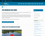
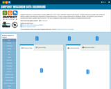
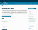
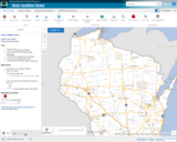
The Surface Water Data Viewer is a mapping tool for the State of Wisconsin. It provides interactive web mapping tools for a variety of datasets, including chemistry, physical, and biological data. The data managed in layers that can be turned on and off as needed. The Homepage of the Surface Water Data Viewer (SWDV) has many commonly used features labeled. Descriptions of the features are as follows:

Toolbars: There are a variety of toolbars with different themes to help complete tasks using the SWDV. The toolbars can be used to display the layers available to the map, add or remove shapes, text, or measurement features, identify points, print maps, and more!

Search Bar: Using the search bar, you can search monitoring stations by number, locations by keyword, and waterbodies by WBIC. Be careful when using the search bar, partial matches do not always appear in the results.

Navigation Pane: The navigation pane is where results will appear from searches, where you are able to select layers for the map, and features for printing. You will be able to refine the data that is shown here, if desired. You can hide the navigation pane by clicking the left-facing arrow at the top.

Coordinates and Coordinate System: The coordinates will display for any point moused-over on the map. Click the black triangle to select your preferred method for displaying lat/long (DD, DMS, DDM, Mercator). The right-most option in this pane allows you to manually manage thescale of the map. Click on the scale tool, and selected the desired scale at which you wish to view the map. Select Go to implement changes.

Scale Bar: The scale bar shows the current extent of the map.

Whole State View: This view describes what is being shown on the main map relative to the entire state. A blue rectangle will cover the region of the state being shown on the map. You can also navigate the map by moving the blue square around the state-view map. If you print a map, this whole state view will print in the corner as a reference. You can minimize this view by clicking the corner-facing arrow in the top left edge of the box.

Show/Hide Toolbar: Use this button to hide the toolbar for a larger view of the map. If you have hidden the toolbar, you can also use this button to show it again.

Subject:
Agriculture, Food and Natural Resources
American Indian Studies
Biology
Botany
Career and Technical Education
Earth and Space Science
Ecology
Education
Elementary Education
Environmental Science
Forestry and Agriculture
Geography
Geology
Higher Education
Hydrology
Life Science
Social Studies
Material Type:
Activity/Lab
Homework/Assignment
Learning Task
Lecture
Lesson
Author:
Wisconsin Department of Natural Resources
Date Added:
03/12/2024
Wisconsin Tornado Information
Only Sharing Permitted
CC BY-NC-ND
Rating
0.0 stars

Wisconsin's Tornadoes for the current and a link to find historical tornadoes from past years (shown on map with details of each tornado). From National Weather Service.

Subject:
Atmospheric Science
Earth and Space Science
Education
Elementary Education
Higher Education
Material Type:
Diagram/Illustration
Interactive
Author:
National Weather Service
Noaa
Us Department Of Commerce
Date Added:
03/12/2024
Wisconsin Water Condition Viewer - Wisconsin DNR
Only Sharing Permitted
CC BY-NC-ND
Rating
0.0 stars

The Water Condition Viewer (WCV) is an interactive mapping tool that focuses on water condition, monitoring, assessment and management data. Data includes Clean Water Act, Monitoring Projects, Healthy Watersheds Assessments, Targeted Watershed Assessments, Wastewater Evaluation, Watershed Planning, County Land and Water Plans, Nine Key Element Plans and more. All datasets from specialized themes are available from this main, general set of layers.

Subject:
Agriculture, Food and Natural Resources
Biology
Botany
Career and Technical Education
Earth and Space Science
Ecology
Education
Elementary Education
Environmental Literacy and Sustainability
Environmental Science
Family and Consumer Sciences
Forestry and Agriculture
Geology
Health Education
Health Science
Hydrology
Life Science
Marketing, Management and Entrepreneurship
Material Type:
Activity/Lab
Homework/Assignment
Lecture
Lesson
Author:
Wisconsin Department of Natural Resources
Date Added:
03/12/2024
Wisconsin's historical Earthquakes - Latest Earthquakes in World - USGS
Only Sharing Permitted
CC BY-NC-ND
Rating
0.0 stars

This is a map showing the location and severity of each of the Earthquakes which have occurred in Wisconsin in recorded history. This site is also where one can find recent or historic earthquakes, lists, information on selected significant earthquakes, earthquake resources by state, or find webservices.

Subject:
Earth and Space Science
Education
Elementary Education
Forestry and Agriculture
Geography
Geology
Life Science
Social Studies
Material Type:
Activity/Lab
Diagram/Illustration
Homework/Assignment
Lecture
Author:
USGS (US Geological Survey)
Date Added:
03/12/2024