Updating search results...

Search Resources

24 Results

View
Selected filters:
  • lake
About Climate Wisconsin – Climate Wisconsin – PBS Wisconsin Education
Only Sharing Permitted
CC BY-ND
Rating
0.0 stars

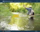
Climate Wisconsin is an educational multimedia collection featuring stories about the impact of climate change in Wisconsin.
LEARNING GOALS:
Expand understanding of how climate change impacts life in Wisconsin.
Connect personal observations to the study of climate and environmental science.
Identify actions that may impact changes to our climate.

Subject:
Agriculture, Food and Natural Resources
Art and Design
Astronomy
Atmospheric Science
Biology
Business and Information Technology
Career and Technical Education
Character Education
Composition and Rhetoric
Earth and Space Science
Ecology
Education
Elementary Education
English Language Arts
Environmental Literacy and Sustainability
Environmental Science
Family and Consumer Sciences
Fine Arts
Forestry and Agriculture
Geography
Geology
Health Education
Health Science
Higher Education
Life Science
Literature
Marketing, Management and Entrepreneurship
Media Arts
Reading Foundation Skills
Reading Informational Text
Reading Literature
Social Studies
Material Type:
Activity/Lab
Diagram/Illustration
Homework/Assignment
Interactive
Author:
PBS Wisconsin Education
Date Added:
04/21/2024
All About Water!
Read the Fine Print
Educational Use
Rating
0.0 stars

Students learn about the differences between types of water (surface and ground), as well as the differences between streams, rivers and lakes. Then, they learn about dissolved organic matter (DOM), and the role it plays in identifying drinking water sources. Finally, students are introduced to conventional drinking water treatment processes.

Subject:
Career and Technical Education
Earth and Space Science
Hydrology
Technology and Engineering
Material Type:
Lesson Plan
Provider:
TeachEngineering
Provider Set:
TeachEngineering NGSS Aligned Resources
Author:
Integrated Teaching and Learning Program,
Jessica Ebert
Marissa H. Forbes
Date Added:
09/18/2014
Anishinaabe Place Names: Wenabozho Ominisan
Conditional Remix & Share Permitted
CC BY-NC-SA
Rating
0.0 stars

This text set focuses on the Anishinaabe names for the Wenabozho Ominisan. Wenabozho is an important Anishinaabe figure, a trickster. Ominisan is the Anishinaabe word for islands. Wenabozho Ominisan (the islands of Wenabozho) is the Anishinaabe way to refer to what is also known as the Apostle Islands archipelago. Some of the Anishinaabe island names and English names are literal translations. Yet, some of the Anishinaabe names describe a characteristic or use of the island in a manner different from the English names. The text set provides resources that will not only allow students to learn the Anishinaabe names but also provide insight into traditional uses and perspectives of these islands. 

Subject:
Earth and Space Science
Education
Environmental Science
Geography
Geology
Global Education
World Languages
Material Type:
Learning Task
Lesson
Reference Material
Author:
Rick Erickson
Date Added:
05/30/2023
Build a River Model!
Rating
0.0 stars

In this activity, you will explore rivers, lakes, and oceans by modeling them inside a pan using aluminum foil, sand, pebbles, and real water!

Subject:
Earth and Space Science
Material Type:
Activity/Lab
Author:
PhD
Science Buddies
Svenja Lohner
Date Added:
03/30/2024
Dane County Water Quality - Land and Water Resources Viewer - Surface Water
Only Sharing Permitted
CC BY-NC-ND
Rating
0.0 stars

Dane County's abundant surface water resources are monitored and assessed primarily by the Wisconsin Department of Natural Resources (WDNR). Major streams and lakes are classified into categories based on the aquatic organisms present. These classifications provide an indication of water quality and fishery conditions.

Agricultural and urban land uses contribute to nutrient rich runoff reaching surface waters. Impervious surfaces and removal of wetlands also increases the flow of stormwater to local waterways. Explore issues facing our surface water and see maps of degraded water resources.

Effective water quality planning depends on long-term assessment and monitoring. The Capital Area Regional Planning Commission uses long-term datasets to evaluate regional trends.

Learn about practices meant to protect the region's streams, shorelands, and lakes.

Dane County
Land and Water Resources Viewer: An interactive county map showing watershed boundaries, thermally sensitive areas, cold water communities and more.

Subject:
Agriculture, Food and Natural Resources
Biology
Botany
Career and Technical Education
Civics and Government
Earth and Space Science
Ecology
Education
Elementary Education
Environmental Literacy and Sustainability
Environmental Science
Family and Consumer Sciences
Forestry and Agriculture
Geology
Health Education
Health Science
Higher Education
Hydrology
Life Science
Social Studies
Material Type:
Activity/Lab
Homework/Assignment
Learning Task
Author:
The Capital Regional Planning Commission
Date Added:
03/12/2024
Fish List – Eat Wisconsin Fish
Conditional Remix & Share Permitted
CC BY-NC
Rating
0.0 stars

Fish Species Commercially Harvested or Raised in Wisconsin for Food
Common names for fish can be different by region.

Subject:
Agriculture, Food and Natural Resources
Art and Design
Business and Information Technology
Career and Technical Education
Early Learning
Ecology
Education
Elementary Education
Environmental Literacy and Sustainability
Family and Consumer Sciences
Fine Arts
Forestry and Agriculture
Health Science
Life Science
Marketing, Management and Entrepreneurship
Zoology
Material Type:
Data Set
Diagram/Illustration
Reference Material
Author:
NOAA
University of Wisconsin - Madison
Sea Grant of Wisconsin
Date Added:
04/21/2024
Fresh or Salty?
Read the Fine Print
Educational Use
Rating
0.0 stars

Between 70 and 75% of the Earth's surface is covered with water and there exists still more water in the atmosphere and underground in aquifers. In this lesson, students learn about water bodies on the planet Earth and their various uses and qualities. They will learn about several ways that engineers are working to maintain and conserve water sources. They will also think about their role in water conservation.

Subject:
Career and Technical Education
Earth and Space Science
Hydrology
Technology and Engineering
Material Type:
Activity/Lab
Lesson Plan
Provider:
TeachEngineering
Provider Set:
TeachEngineering NGSS Aligned Resources
Author:
Integrated Teaching and Learning Program,
Janet Yowell
Malinda Schaefer Zarske
Sara Born
Date Added:
09/18/2014
Laurentide Ice Sheet: Ice-Margin Positions in Wisconsin (2nd edition)
Unrestricted Use
CC BY
Rating
0.0 stars

Series of 43 page-size maps showing the chronology of the last glaciation's advances and retreats across Wisconsin. Includes a brief discussion about how the maps were made, how lake positions were determined, as well as a list of selected references.

Subject:
Earth and Space Science
Environmental Science
Forestry and Agriculture
Geology
Hydrology
Life Science
Material Type:
Data Set
Diagram/Illustration
Author:
D.M.; Attig
J.W.;
Mickelson
Date Added:
02/20/2024
PFAS Interactive Data Viewer - Wisconsin Department of Natural Resources
Only Sharing Permitted
CC BY-NC-ND
Rating
0.0 stars

The PFAS Interactive Data Viewer is a mapping tool that incorporates datasets from several DNR programs to show locations throughout Wisconsin that have been impacted by PFAS.

Information included in the PFAS Interactive Data Viewer include locations with known PFAS contamination and whether clean up has been completed; results from testing municipal drinking water for PFAS; locations with PFAS-related fish and game consumption advisories; and waterbodies throughout Wisconsin sampled for PFAS during targeted or routine monitoring.

These data may not reflect current PFAS levels at specific locations.

Subject:
Agriculture, Food and Natural Resources
Anatomy/Physiology
Biology
Career and Technical Education
Chemistry
Civics and Government
Earth and Space Science
Ecology
Environmental Science
Family and Consumer Sciences
Forestry and Agriculture
Geology
Health Science
Hydrology
Life Science
Marketing, Management and Entrepreneurship
Physical Science
Social Studies
Technology and Engineering
Material Type:
Data Set
Diagram/Illustration
Interactive
Author:
Wisconsin Department of Natural Resources
Date Added:
03/12/2024
Protecting Wisconsin's Biodiversity
Conditional Remix & Share Permitted
CC BY-NC
Rating
0.0 stars

Biodiversity is a shortened form of the term "biological diversity." The entire spectrum of life forms and the many ecological processes support them. Wisconsin is blessed with abundant biodiversity. Located at the junction of the eastern deciduous forest, northern boreal forest and temperate grasslands, we have a wealth of species and natural communities.

Approximately 1,800 species of native plants and close to 700 species of native vertebrates have been identified in Wisconsin. In addition, there are thousands of species of non-vascular plants and invertebrates. These pages highlight the uncommon and rare species, natural communities, geological features and essential habitat areas throughout Wisconsin.

Subject:
Agriculture, Food and Natural Resources
Biology
Botany
Career and Technical Education
Early Learning
Ecology
Education
Elementary Education
Environmental Science
Forestry and Agriculture
Health Science
Life Science
Zoology
Material Type:
Activity/Lab
Data Set
Interactive
Author:
Wisconsin Department of Natural Resources
Date Added:
04/21/2024
Water Clarity Monitoring - Extension Lakes
Unrestricted Use
Public Domain
Rating
0.0 stars

Water clarity monitoring is a process in which the volunteer lowers an 8” diameter, black & white disc (“Secchi disc”) into the deepest part of the lake to determine how far down they can see the disc as it is lowered. Water clarity monitoring is done every 10-14 days throughout the open-water season. Water clarity is a quick way to estimate lake health, and it plays an important role in determining the types of plants and animals that a water body can support.

Can also add in collected data for Water Chemistry analysis along with Secchi disc collected data.

This site includes data collection forms for individuals or groups to add their data from their own lake to this dataset.

Subject:
Agriculture, Food and Natural Resources
Biology
Career and Technical Education
Ecology
Environmental Science
Life Science
Material Type:
Activity/Lab
Homework/Assignment
Lesson
Author:
Paul Skawinski
college of Natural Resources
University of Wisconsin Stevens Point
Date Added:
04/24/2024
Water Resources of the United States—National Water Information System (NWIS) Mapper - USGS
Only Sharing Permitted
CC BY-NC-ND
Rating
0.0 stars

The National Water Information System (NWIS) Mapper provides access to over 1.5 million sites contained in the USGS National Water Information System (NWIS), including sites where current and historical surface-water, groundwater, springs, and atmospheric data has been collected. Users can search by site type, data type, site number, or place.

Subject:
Agriculture, Food and Natural Resources
Atmospheric Science
Business and Information Technology
Career and Technical Education
Earth and Space Science
Ecology
Education
Elementary Education
English Language Arts
Environmental Literacy and Sustainability
Environmental Science
Forestry and Agriculture
Geography
Geology
Health Education
Health Science
Higher Education
Hydrology
Life Science
Literature
Marketing, Management and Entrepreneurship
Oceanography
Social Studies
Technology and Engineering
Material Type:
Activity/Lab
Homework/Assignment
Author:
USGS (US Geological Survey)
Date Added:
03/12/2024
Wisconsin Lakes Data - Lake Water Quality Data - Lake Maps - Plants and Aquatic Insects
Unrestricted Use
Public Domain
Rating
0.0 stars

Wisconsin's 15,000 lakes. The DNR partners with the University of Wisconsin - Extension and citizens around the state to help protect and maintain these amazing natural resources while providing some of the best recreational opportunities in the nation. More than 600 lake organizations and thousands of volunteers play a leadership role in the stewardship of Wisconsin's lakes.

Find a Lake, Lake Water Quality Data, Lake Maps, Plants and Aquatic invasive Insects - are all linked to this site.

Subject:
Agriculture, Food and Natural Resources
Art and Design
Biology
Botany
Career and Technical Education
Ecology
Environmental Literacy and Sustainability
Environmental Science
Fine Arts
Forestry and Agriculture
Life Science
Zoology
Material Type:
Activity/Lab
Data Set
Diagram/Illustration
Interactive
Author:
Wisconsin Department of Natural Resources
Date Added:
04/23/2024
Wisconsin Lakes - Water Quality Data for each lake by County
Unrestricted Use
Public Domain
Rating
0.0 stars

Volunteers, DNR staff, county staff and others collect water clarity, temperature and dissolved oxygen, as well as other water quality data, on lakes across Wisconsin. Around 1,000 volunteers are currently active, and the network has been going strong since 1986. Water clarity is measured with a black and white disk called a "Secchi Disk".

Satellite images are used to retrieve water clarity data for lakes across the state. This effort began in 1999 when the University of Wisconsin-Madison Environmental Remote Sensing Center (ERSC) developed a model for the retrieval of water clarity data from satellite images and Citizen Lake Monitoring Network volunteers provided on-the-ground Secchi data to calibrate this model for each satellite image. Water clarity data was retrieved for over 8,000 lakes statewide between 1999 and 2001. The DNR continues to analyze data in this way today in its remote sensing program.

Subject:
Agriculture, Food and Natural Resources
Biology
Career and Technical Education
Ecology
Environmental Science
Forestry and Agriculture
Life Science
Marketing, Management and Entrepreneurship
Material Type:
Data Set
Diagram/Illustration
Other
Author:
Wisconsin Department of Natural Resources
Date Added:
04/24/2024
Wisconsin Rocks and Minerals - Interactive Storymap
Only Sharing Permitted
CC BY-NC-ND
Rating
0.0 stars

The Badger State is home to a wide variety of rocks and minerals, some of which you may find familiar and others you may not recognize. In this interactive guide, the Wisconsin Geological and Natural History Survey takes you on a journey through the state, exploring our most important rocks and minerals.

Subject:
Earth and Space Science
Ecology
Education
Elementary Education
Environmental Science
Forestry and Agriculture
Geology
Higher Education
Hydrology
Life Science
Material Type:
Activity/Lab
Homework/Assignment
Lesson
Author:
Wisconsin Geological and Natural History Survey
Date Added:
03/04/2024
Wisconsin State Parks
Unrestricted Use
Public Domain
Rating
0.0 stars

The Wisconsin State Park System provides places for outdoor recreation and for learning about nature and conservation. State parks, forests, trails and recreation areas see more than 20 million visits a year. Come and join the fun!

This site has links to all of the State Parks, Forests, Trails and recreation areas in Wisconsin.

Subject:
Agriculture, Food and Natural Resources
Art and Design
Astronomy
Atmospheric Science
Biology
Botany
Career and Technical Education
Earth and Space Science
Ecology
Education
Elementary Education
Environmental Literacy and Sustainability
Environmental Science
Fine Arts
Forestry and Agriculture
Geography
Geology
Higher Education
Life Science
Marketing, Management and Entrepreneurship
Social Studies
Material Type:
Other
Reference Material
Author:
Wisconsin Department of Natural Resources
Date Added:
04/24/2024
Wisconsin Surface Water Data Viewer
Conditional Remix & Share Permitted
CC BY-NC
Rating
0.0 stars

The Surface Water Data Viewer is a mapping tool for the State of Wisconsin. It provides interactive web mapping tools for a variety of datasets, including chemistry, physical, and biological data. The data managed in layers that can be turned on and off as needed. The Homepage of the Surface Water Data Viewer (SWDV) has many commonly used features labeled. Descriptions of the features are as follows:

Toolbars: There are a variety of toolbars with different themes to help complete tasks using the SWDV. The toolbars can be used to display the layers available to the map, add or remove shapes, text, or measurement features, identify points, print maps, and more!

Search Bar: Using the search bar, you can search monitoring stations by number, locations by keyword, and waterbodies by WBIC. Be careful when using the search bar, partial matches do not always appear in the results.

Navigation Pane: The navigation pane is where results will appear from searches, where you are able to select layers for the map, and features for printing. You will be able to refine the data that is shown here, if desired. You can hide the navigation pane by clicking the left-facing arrow at the top.

Coordinates and Coordinate System: The coordinates will display for any point moused-over on the map. Click the black triangle to select your preferred method for displaying lat/long (DD, DMS, DDM, Mercator). The right-most option in this pane allows you to manually manage thescale of the map. Click on the scale tool, and selected the desired scale at which you wish to view the map. Select Go to implement changes.

Scale Bar: The scale bar shows the current extent of the map.

Whole State View: This view describes what is being shown on the main map relative to the entire state. A blue rectangle will cover the region of the state being shown on the map. You can also navigate the map by moving the blue square around the state-view map. If you print a map, this whole state view will print in the corner as a reference. You can minimize this view by clicking the corner-facing arrow in the top left edge of the box.

Show/Hide Toolbar: Use this button to hide the toolbar for a larger view of the map. If you have hidden the toolbar, you can also use this button to show it again.

Subject:
Agriculture, Food and Natural Resources
American Indian Studies
Biology
Botany
Career and Technical Education
Earth and Space Science
Ecology
Education
Elementary Education
Environmental Science
Forestry and Agriculture
Geography
Geology
Higher Education
Hydrology
Life Science
Social Studies
Material Type:
Activity/Lab
Homework/Assignment
Learning Task
Lecture
Lesson
Author:
Wisconsin Department of Natural Resources
Date Added:
03/12/2024
Wisconsin Water Condition Viewer - Wisconsin DNR
Only Sharing Permitted
CC BY-NC-ND
Rating
0.0 stars

The Water Condition Viewer (WCV) is an interactive mapping tool that focuses on water condition, monitoring, assessment and management data. Data includes Clean Water Act, Monitoring Projects, Healthy Watersheds Assessments, Targeted Watershed Assessments, Wastewater Evaluation, Watershed Planning, County Land and Water Plans, Nine Key Element Plans and more. All datasets from specialized themes are available from this main, general set of layers.

Subject:
Agriculture, Food and Natural Resources
Biology
Botany
Career and Technical Education
Earth and Space Science
Ecology
Education
Elementary Education
Environmental Literacy and Sustainability
Environmental Science
Family and Consumer Sciences
Forestry and Agriculture
Geology
Health Education
Health Science
Hydrology
Life Science
Marketing, Management and Entrepreneurship
Material Type:
Activity/Lab
Homework/Assignment
Lecture
Lesson
Author:
Wisconsin Department of Natural Resources
Date Added:
03/12/2024
Wisconsin Water Quantity Data Viewer - Wisconsin DNR
Only Sharing Permitted
CC BY-NC-ND
Rating
0.0 stars

This map viewer was created for use by the general public to view water quantity data collected by Wisconsin DNR (WDNR), the US Geological Survey (UGSG) and the Wisconsin Geological and Natural History Survey (WGNHS).

This viewer also provides a means for the public to view pending high capacity well applications and recently approved wells. As required by Wisconsin law, these locations are generalized to display at the public land survey section level. Therefore, any well or surface water intake is symbolized by the section in which is located. Clicking identify on sections may return multiple records, one for each data point. This viewer contains a number of layer groups:

Well Applications and Approvals – This layer displays the locations of pending and approved high capacity well applications. It includes:
High capacity wells that have been applied for by the owner but have not yet been approved by the Department
High capacity wells approved in the last 30 days
High capacity wells approved by WDNR but that have not yet been constructed

High Capacity Withdrawal Locations – This layer show the location of high capacity wells constructed and available for use as well as currently registered high capacity surface water withdrawals. It includes:

Existing high capacity wells
Existing surface water withdrawals

USGS Water Quantity Monitoring – This layer shows the locations of groundwater level monitoring points, streamflow gages, and lake level gages monitored and recorded by USGS. It includes currently active monitoring locations as well as historical monitoring locations. Symbol sizes are scaled according to the number of measurements taken at each location.

WDNR Water Quantity Monitoring Groundwater Protection Features – This layer shows the locations of streamflow and lake level measurements maintained by WDNR. It includes a variety of measurement types taken by WDNR staff, partner organizations, county staff and volunteers.

WGNHS Spring Monitoring – This layer shows the location of springs surveyed by WGNHS staff between 2015 and 2017. Note that spring flow varies seasonally and annually. In addition, many spring locations are located on private land and not accessible by the public without landowner permission.

Groundwater Protection Features – This layer displays the locations of groundwater protection features as defined by Wisconsin Rule NR820. It includes trout streams, outstanding and exceptional water resources, and springs with a flow rate surveyed by WGNHS of 1 cubic foot per second (CFS) or greater. Note that all 1 CFS may not have been surveyed.

Guidance for how to use WDNR Geocortex viewers can be found here. For more information, please contact the water use section at 608-266-2299 or at DNRWATERUSEREGISTRATION@wisconsin.gov

Subject:
Agriculture, Food and Natural Resources
Biology
Business and Information Technology
Career and Technical Education
Earth and Space Science
Ecology
Education
Elementary Education
Environmental Science
Forestry and Agriculture
Geology
Health Science
Higher Education
Hydrology
Life Science
Marketing, Management and Entrepreneurship
Material Type:
Activity/Lab
Homework/Assignment
Lecture
Lesson
Author:
Wisconsin Department of Natural Resources
Date Added:
03/12/2024
Wisconsin Weather and Soil Monitoring Station Interactive map Mesonet - Wisconsin State Climatology Office
Unrestricted Use
Public Domain
Rating
0.0 stars

The Wisconsin Environmental Mesonet (WiscoNet) is a growing network of weather and soil monitoring stations across Wisconsin, designed to provide high quality data at high spatial and temporal resolutions. There are currently 14 Wisconet stations with plans to expand to around 90 by 2026. Each Wisconet station provides more than one dozen measurements every 5 minutes.

The stations measure temperature, dew point, wind, rain, soil moisture and temperature, and more.

You can view data through an interactive map or a list of stations.

Subject:
Agriculture, Food and Natural Resources
Career and Technical Education
Material Type:
Activity/Lab
Diagram/Illustration
Homework/Assignment
Interactive
Author:
Wisconsin State Climatology Office and Nelson Institute for Environmental Studies
Date Added:
04/28/2024