Updating search results...

Search Resources

21 Results

View
Selected filters:
Black bear population in Wisconsin - status and distribution
Conditional Remix & Share Permitted
CC BY-NC
Rating
0.0 stars

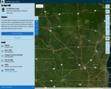
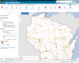
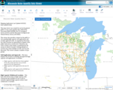
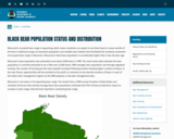
Wisconsin's occupied bear range is expanding, which means residents can expect to see black bears in areas outside of the bear's traditional range. An abundant population and suitable bear habitat have facilitated the southerly movement of occupied bear range in Wisconsin. Wisconsin's black bear population is considerably higher than it was 30 years ago.

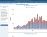
Wisconsin's bear population was estimated to be about 9,000 bears in 1989. The most recent data indicates the bear population is currently estimated to be a little over 24,000 bears. DNR manages bear population size through regulated hunting. The number of hunting permits have steadily increased following studies showing higher numbers of bears. In the near future, opportunities will be provided to the public to comment on the desired numbers of bears in each of the state's bear management regions as the DNR prepares a new bear management plan.

Wisconsin is not alone in its expanding bear range. The results from a 2008 survey of eastern United States and Canadian Provinces that actively manage black bear populations indicated that 75% of these jurisdictions report an increase in bear range. Only Vermont reported a contracting bear range.

Subject:
Agriculture, Food and Natural Resources
Biology
Career and Technical Education
Ecology
Environmental Science
Forestry and Agriculture
Life Science
Zoology
Material Type:
Data Set
Diagram/Illustration
Interactive
Author:
Wisconsin Department of Natural Resources
Date Added:
04/21/2024
Deer Statistics in Wisconsin - Total Deer Harvest - Wisconsin Department of Natural Resources
Only Sharing Permitted
CC BY-NC-ND
Rating
0.0 stars

This Data set and graphs show the Deer harvest each year (1960-present) in Wisconsin for both the state and for each county.

Subject:
Agriculture, Food and Natural Resources
Biology
Career and Technical Education
Ecology
Economics
Education
Elementary Education
Environmental Science
Family and Consumer Sciences
Forestry and Agriculture
Higher Education
Life Science
Marketing, Management and Entrepreneurship
Social Studies
Zoology
Material Type:
Activity/Lab
Diagram/Illustration
Interactive
Lesson
Author:
Wisconsin Department of Natural Resources
Date Added:
03/12/2024
Elk in Wisconsin
Conditional Remix & Share Permitted
CC BY-NC
Rating
0.0 stars

Once widespread here and across North America, elk were eliminated from Wisconsin in the 1880s due to unregulated hunting and habitat loss. Over 130 years later, they once again live in our state's central and northern forest regions. From a population of 25 elk reintroduced in 1995, and with the help of the second reintroduction effort that started in 2015, the state's total elk population has now surpassed 400 animals.

Thanks to the support of multiple partners and the backing of Wisconsin citizens, the bugle of rutting September bulls is back and here to stay!

Elk (Cervus canadensis) is one of North America's most significant deer family members (Cervidae), second only to moose. Wisconsin's native elk (before European settlement) belonged to the Eastern elk subspecies (C. c. canadensis), believed to have gone extinct during the late 1800s. The Rocky Mountain sub-species (C. c. nelsoni) was later used in reintroduction efforts in Wisconsin and other eastern U.S. states.

Elk is one of three members of the deer family that lives in Wisconsin regularly, with the other two being white-tailed deer (Odocoileus virginianus) and moose (Alces alces). Elk are approximately three times larger than deer and about two-thirds the size of moose. Adult elk are light tan-colored with a darker mane on their neck with a distinct buff-colored rump patch and stub tail.

Elk vary in size by sex. A mature cow stands approximately four and a half feet tall at the shoulder, six and a half feet in length from nose to tail and weighs 500-650 pounds. In contrast, a mature bull may stand five feet or more at the shoulder, stretch over eight feet long and weigh 600-900 pounds. Wisconsin elk calves typically weigh between 35-40 pounds at birth. Calves are born with white spots to help them blend into their surroundings during their first few months. Elk are also a herd-associated species that have many vocalizations and unique characteristics.

Subject:
Agriculture, Food and Natural Resources
Career and Technical Education
Ecology
Environmental Literacy and Sustainability
Environmental Science
Forestry and Agriculture
Life Science
Zoology
Material Type:
Data Set
Interactive
Author:
Wisconsin Department of Natural Resources
Date Added:
04/21/2024
Fish ID Tool - Wisconsin Sea Grant
Conditional Remix & Share Permitted
CC BY-NC
Rating
0.0 stars

This fish identification tool was developed by the University of Wisconsin Center for Limnology, Wisconsin Department of Natural Resources, and the University of Wisconsin Sea Grant Institute.

Carry 174 Wisconsin fish in your pocket! Download the mobile app and you can identify Wisconsin fish wherever you go, no internet connection required.

Subject:
Agriculture, Food and Natural Resources
Career and Technical Education
Early Learning
Ecology
Education
Elementary Education
Environmental Science
Family and Consumer Sciences
Forestry and Agriculture
Life Science
Zoology
Material Type:
Activity/Lab
Homework/Assignment
Other
Author:
Wisconsin Department of Natural Resources
Wisconsin Sea Grant
Date Added:
04/21/2024
Ice Age Trail in Wisconsin -Interactive map
Unrestricted Use
CC BY
Rating
0.0 stars

This data layer includes lines representing existing sections of the Ice Age National Scenic Trail. This version of the data is hosted by Wisconsin DNR for DNR staff use and public download and is updated approximately every two months.

This layer is hosted by Wisconsin DNR, and reflects Ice Age Trail updates received from the Ice Age Trail Alliance on December 21st, 2023. This layer is typically updated approximately every two months and is primarily for the purpose of DNR staff use and public download from DNR's Open Data Portal. For more current trail data contact Tiffany Stram (tiffany@iceagetrail.org) GIS/Technology Specialist at Ice Age Trail Alliance. For the official depiction of Ice Age Trails in Wisconsin, see Ice Age Trail Alliance's Ice Age National Scenic Trail Existing Sections - Official Layer: https://www.arcgis.com/home/item.html?id=735b25ad50e74520b7396d9168f53cfc.

This data layer includes lines representing existing sections of the Ice Age National Scenic Trail. This layer is a combination of GPS and digitized data, merged to represent one complete data layer for the IAT. The data was developed by the Ice Age Trail Alliance (IATA) in cooperation with the National Park Service's Ice Age Trail Office.

Subject:
Agriculture, Food and Natural Resources
Business and Information Technology
Career and Technical Education
Civics and Government
Earth and Space Science
Ecology
Education
Elementary Education
Environmental Science
Forestry and Agriculture
Geography
Geology
Higher Education
Life Science
Marketing, Management and Entrepreneurship
Social Studies
Material Type:
Data Set
Diagram/Illustration
Interactive
Other
Reference Material
Author:
Wisconsin DNR Data Curator
Wisconsin Department of Natural Resources
Date Added:
03/12/2024
Look up Groundwater and Well Data for Private and Public wells in Wisconsin - Wisconsin Department of Natural Resources
Unrestricted Use
CC BY
Rating
0.0 stars

Wisconsin DNR link to look up most private or public wells. Can use Map View or by unique Well ID number. Well construction information, including geology, construction method, well depth, water depth, well yield and other information about the well.

Subject:
Agriculture, Food and Natural Resources
Career and Technical Education
Earth and Space Science
Ecology
Environmental Science
Forestry and Agriculture
Geography
Geology
Health Science
Hydrology
Life Science
Social Studies
Material Type:
Activity/Lab
Formative Assessment
Learning Task
Lesson
Reference Material
Author:
Wisconsin Department of Natural Resources
Date Added:
01/10/2024
PFAS Interactive Data Viewer - Wisconsin Department of Natural Resources
Only Sharing Permitted
CC BY-NC-ND
Rating
0.0 stars

The PFAS Interactive Data Viewer is a mapping tool that incorporates datasets from several DNR programs to show locations throughout Wisconsin that have been impacted by PFAS.

Information included in the PFAS Interactive Data Viewer include locations with known PFAS contamination and whether clean up has been completed; results from testing municipal drinking water for PFAS; locations with PFAS-related fish and game consumption advisories; and waterbodies throughout Wisconsin sampled for PFAS during targeted or routine monitoring.

These data may not reflect current PFAS levels at specific locations.

Subject:
Agriculture, Food and Natural Resources
Anatomy/Physiology
Biology
Career and Technical Education
Chemistry
Civics and Government
Earth and Space Science
Ecology
Environmental Science
Family and Consumer Sciences
Forestry and Agriculture
Geology
Health Science
Hydrology
Life Science
Marketing, Management and Entrepreneurship
Physical Science
Social Studies
Technology and Engineering
Material Type:
Data Set
Diagram/Illustration
Interactive
Author:
Wisconsin Department of Natural Resources
Date Added:
03/12/2024
Protecting Wisconsin's Biodiversity
Conditional Remix & Share Permitted
CC BY-NC
Rating
0.0 stars

Biodiversity is a shortened form of the term "biological diversity." The entire spectrum of life forms and the many ecological processes support them. Wisconsin is blessed with abundant biodiversity. Located at the junction of the eastern deciduous forest, northern boreal forest and temperate grasslands, we have a wealth of species and natural communities.

Approximately 1,800 species of native plants and close to 700 species of native vertebrates have been identified in Wisconsin. In addition, there are thousands of species of non-vascular plants and invertebrates. These pages highlight the uncommon and rare species, natural communities, geological features and essential habitat areas throughout Wisconsin.

Subject:
Agriculture, Food and Natural Resources
Biology
Botany
Career and Technical Education
Early Learning
Ecology
Education
Elementary Education
Environmental Science
Forestry and Agriculture
Health Science
Life Science
Zoology
Material Type:
Activity/Lab
Data Set
Interactive
Author:
Wisconsin Department of Natural Resources
Date Added:
04/21/2024
Snapshot Wisconsin Data Dashboard
Conditional Remix & Share Permitted
CC BY-NC
Rating
0.0 stars

Snapshot Wisconsin is a partnership to monitor wildlife year-round, using a statewide network of trail cameras. Snapshot Wisconsin provides data needed for decision making at the Wisconsin Department of Natural Resources. It is also a unique opportunity for individuals, families, and students to get involved in monitoring the state’s valuable natural resources. This tool is designed to help visualize many aspects of Snapshot Wisconsin data.

Subject:
Agriculture, Food and Natural Resources
Art and Design
Biology
Career and Technical Education
Ecology
Environmental Science
Fine Arts
Forestry and Agriculture
Genetics
Life Science
Marketing, Management and Entrepreneurship
Zoology
Material Type:
Data Set
Interactive
Other
Reference Material
Author:
SnapShot Wisconsin
Wildlife Restoration
Wisconsin Department of Natural Resources
Date Added:
04/21/2024
Wisconsin DNR Open Data Portal
Only Sharing Permitted
CC BY-NC-ND
Rating
0.0 stars

This is the Wisconsin Department of Natural Resources GIS Open Data Portal. It is a free resource for locating, viewing, and downloading data developed and/or maintained by the Wisconsin DNR.

This site also has categories of: Water, Fish and Wildlife, Managed Lands, Cimate, Parks and Recreation, Forestry, Transportation, Indexess and PLSS, Boundaries and Land Cover and Vegetation.

The site also has Applications that include: PFAS in Wisconsin Data Viewer, Western Coulee and Ridges Regional Master Plan, North Central Forest Regional Master Plan, Wildfires Dashboard App, Report Invasive Species, CWD reporting, etc

Subject:
Agriculture, Food and Natural Resources
Biology
Botany
Career and Technical Education
Civics and Government
Earth and Space Science
Ecology
Education
Elementary Education
Environmental Literacy and Sustainability
Environmental Science
Forestry and Agriculture
Geography
Geology
Health Education
Health Science
Higher Education
Hydrology
Life Science
Social Studies
Zoology
Material Type:
Activity/Lab
Homework/Assignment
Learning Task
Lecture
Lesson
Lesson Plan
Author:
Wisconsin Department of Natural Resources
Date Added:
03/12/2024
Wisconsin Lakes Data - Lake Water Quality Data - Lake Maps - Plants and Aquatic Insects
Unrestricted Use
Public Domain
Rating
0.0 stars

Wisconsin's 15,000 lakes. The DNR partners with the University of Wisconsin - Extension and citizens around the state to help protect and maintain these amazing natural resources while providing some of the best recreational opportunities in the nation. More than 600 lake organizations and thousands of volunteers play a leadership role in the stewardship of Wisconsin's lakes.

Find a Lake, Lake Water Quality Data, Lake Maps, Plants and Aquatic invasive Insects - are all linked to this site.

Subject:
Agriculture, Food and Natural Resources
Art and Design
Biology
Botany
Career and Technical Education
Ecology
Environmental Literacy and Sustainability
Environmental Science
Fine Arts
Forestry and Agriculture
Life Science
Zoology
Material Type:
Activity/Lab
Data Set
Diagram/Illustration
Interactive
Author:
Wisconsin Department of Natural Resources
Date Added:
04/23/2024
Wisconsin Lakes - Water Quality Data for each lake by County
Unrestricted Use
Public Domain
Rating
0.0 stars

Volunteers, DNR staff, county staff and others collect water clarity, temperature and dissolved oxygen, as well as other water quality data, on lakes across Wisconsin. Around 1,000 volunteers are currently active, and the network has been going strong since 1986. Water clarity is measured with a black and white disk called a "Secchi Disk".

Satellite images are used to retrieve water clarity data for lakes across the state. This effort began in 1999 when the University of Wisconsin-Madison Environmental Remote Sensing Center (ERSC) developed a model for the retrieval of water clarity data from satellite images and Citizen Lake Monitoring Network volunteers provided on-the-ground Secchi data to calibrate this model for each satellite image. Water clarity data was retrieved for over 8,000 lakes statewide between 1999 and 2001. The DNR continues to analyze data in this way today in its remote sensing program.

Subject:
Agriculture, Food and Natural Resources
Biology
Career and Technical Education
Ecology
Environmental Science
Forestry and Agriculture
Life Science
Marketing, Management and Entrepreneurship
Material Type:
Data Set
Diagram/Illustration
Other
Author:
Wisconsin Department of Natural Resources
Date Added:
04/24/2024
Wisconsin State Parks
Unrestricted Use
Public Domain
Rating
0.0 stars

The Wisconsin State Park System provides places for outdoor recreation and for learning about nature and conservation. State parks, forests, trails and recreation areas see more than 20 million visits a year. Come and join the fun!

This site has links to all of the State Parks, Forests, Trails and recreation areas in Wisconsin.

Subject:
Agriculture, Food and Natural Resources
Art and Design
Astronomy
Atmospheric Science
Biology
Botany
Career and Technical Education
Earth and Space Science
Ecology
Education
Elementary Education
Environmental Literacy and Sustainability
Environmental Science
Fine Arts
Forestry and Agriculture
Geography
Geology
Higher Education
Life Science
Marketing, Management and Entrepreneurship
Social Studies
Material Type:
Other
Reference Material
Author:
Wisconsin Department of Natural Resources
Date Added:
04/24/2024
Wisconsin Surface Water Data Viewer
Conditional Remix & Share Permitted
CC BY-NC
Rating
0.0 stars

The Surface Water Data Viewer is a mapping tool for the State of Wisconsin. It provides interactive web mapping tools for a variety of datasets, including chemistry, physical, and biological data. The data managed in layers that can be turned on and off as needed. The Homepage of the Surface Water Data Viewer (SWDV) has many commonly used features labeled. Descriptions of the features are as follows:

Toolbars: There are a variety of toolbars with different themes to help complete tasks using the SWDV. The toolbars can be used to display the layers available to the map, add or remove shapes, text, or measurement features, identify points, print maps, and more!

Search Bar: Using the search bar, you can search monitoring stations by number, locations by keyword, and waterbodies by WBIC. Be careful when using the search bar, partial matches do not always appear in the results.

Navigation Pane: The navigation pane is where results will appear from searches, where you are able to select layers for the map, and features for printing. You will be able to refine the data that is shown here, if desired. You can hide the navigation pane by clicking the left-facing arrow at the top.

Coordinates and Coordinate System: The coordinates will display for any point moused-over on the map. Click the black triangle to select your preferred method for displaying lat/long (DD, DMS, DDM, Mercator). The right-most option in this pane allows you to manually manage thescale of the map. Click on the scale tool, and selected the desired scale at which you wish to view the map. Select Go to implement changes.

Scale Bar: The scale bar shows the current extent of the map.

Whole State View: This view describes what is being shown on the main map relative to the entire state. A blue rectangle will cover the region of the state being shown on the map. You can also navigate the map by moving the blue square around the state-view map. If you print a map, this whole state view will print in the corner as a reference. You can minimize this view by clicking the corner-facing arrow in the top left edge of the box.

Show/Hide Toolbar: Use this button to hide the toolbar for a larger view of the map. If you have hidden the toolbar, you can also use this button to show it again.

Subject:
Agriculture, Food and Natural Resources
American Indian Studies
Biology
Botany
Career and Technical Education
Earth and Space Science
Ecology
Education
Elementary Education
Environmental Science
Forestry and Agriculture
Geography
Geology
Higher Education
Hydrology
Life Science
Social Studies
Material Type:
Activity/Lab
Homework/Assignment
Learning Task
Lecture
Lesson
Author:
Wisconsin Department of Natural Resources
Date Added:
03/12/2024
Wisconsin Water Condition Viewer - Wisconsin DNR
Only Sharing Permitted
CC BY-NC-ND
Rating
0.0 stars

The Water Condition Viewer (WCV) is an interactive mapping tool that focuses on water condition, monitoring, assessment and management data. Data includes Clean Water Act, Monitoring Projects, Healthy Watersheds Assessments, Targeted Watershed Assessments, Wastewater Evaluation, Watershed Planning, County Land and Water Plans, Nine Key Element Plans and more. All datasets from specialized themes are available from this main, general set of layers.

Subject:
Agriculture, Food and Natural Resources
Biology
Botany
Career and Technical Education
Earth and Space Science
Ecology
Education
Elementary Education
Environmental Literacy and Sustainability
Environmental Science
Family and Consumer Sciences
Forestry and Agriculture
Geology
Health Education
Health Science
Hydrology
Life Science
Marketing, Management and Entrepreneurship
Material Type:
Activity/Lab
Homework/Assignment
Lecture
Lesson
Author:
Wisconsin Department of Natural Resources
Date Added:
03/12/2024
Wisconsin Water Quantity Data Viewer - Wisconsin DNR
Only Sharing Permitted
CC BY-NC-ND
Rating
0.0 stars

This map viewer was created for use by the general public to view water quantity data collected by Wisconsin DNR (WDNR), the US Geological Survey (UGSG) and the Wisconsin Geological and Natural History Survey (WGNHS).

This viewer also provides a means for the public to view pending high capacity well applications and recently approved wells. As required by Wisconsin law, these locations are generalized to display at the public land survey section level. Therefore, any well or surface water intake is symbolized by the section in which is located. Clicking identify on sections may return multiple records, one for each data point. This viewer contains a number of layer groups:

Well Applications and Approvals – This layer displays the locations of pending and approved high capacity well applications. It includes:
High capacity wells that have been applied for by the owner but have not yet been approved by the Department
High capacity wells approved in the last 30 days
High capacity wells approved by WDNR but that have not yet been constructed

High Capacity Withdrawal Locations – This layer show the location of high capacity wells constructed and available for use as well as currently registered high capacity surface water withdrawals. It includes:

Existing high capacity wells
Existing surface water withdrawals

USGS Water Quantity Monitoring – This layer shows the locations of groundwater level monitoring points, streamflow gages, and lake level gages monitored and recorded by USGS. It includes currently active monitoring locations as well as historical monitoring locations. Symbol sizes are scaled according to the number of measurements taken at each location.

WDNR Water Quantity Monitoring Groundwater Protection Features – This layer shows the locations of streamflow and lake level measurements maintained by WDNR. It includes a variety of measurement types taken by WDNR staff, partner organizations, county staff and volunteers.

WGNHS Spring Monitoring – This layer shows the location of springs surveyed by WGNHS staff between 2015 and 2017. Note that spring flow varies seasonally and annually. In addition, many spring locations are located on private land and not accessible by the public without landowner permission.

Groundwater Protection Features – This layer displays the locations of groundwater protection features as defined by Wisconsin Rule NR820. It includes trout streams, outstanding and exceptional water resources, and springs with a flow rate surveyed by WGNHS of 1 cubic foot per second (CFS) or greater. Note that all 1 CFS may not have been surveyed.

Guidance for how to use WDNR Geocortex viewers can be found here. For more information, please contact the water use section at 608-266-2299 or at DNRWATERUSEREGISTRATION@wisconsin.gov

Subject:
Agriculture, Food and Natural Resources
Biology
Business and Information Technology
Career and Technical Education
Earth and Space Science
Ecology
Education
Elementary Education
Environmental Science
Forestry and Agriculture
Geology
Health Science
Higher Education
Hydrology
Life Science
Marketing, Management and Entrepreneurship
Material Type:
Activity/Lab
Homework/Assignment
Lecture
Lesson
Author:
Wisconsin Department of Natural Resources
Date Added:
03/12/2024
Wisconsin Wetland Inventory Geodatabase
Conditional Remix & Share Permitted
CC BY-NC
Rating
0.0 stars

Wisconsin DNR's Wisconsin Wetland Inventory geodatabase, containing wetland polygons and points.

The principal focus of the wetland inventory is to produce wetland maps that are graphic representations of the type, size and location of wetlands in Wisconsin. Currently, there are two different datasets that have been created using different mapping methods and technologies.

The majority of the state was mapped using traditional stereo-pair, black-and-white, infrared photography. Within this context, the objective was to provide reconnaissance level information on the location, type, size of these habitats such that they are accurate at the nominal scale of the 1:24,000 (1 inch = 2000 feet) base map.

LiDAR Technology:
LiDAR has advanced the ability to see and map wetland and surface water features.

New wetland mapping is underway in areas across the state at a nominal scale of 1:2000 (1 inch = 166.7 feet). The data are being mapped according to the National Wetland Inventory standards using new methods. Please see the WWI SOP for more information.

Subject:
Agriculture, Food and Natural Resources
Biology
Botany
Career and Technical Education
Earth and Space Science
Ecology
Environmental Literacy and Sustainability
Environmental Science
Forestry and Agriculture
Hydrology
Life Science
Marketing, Management and Entrepreneurship
Technology and Engineering
Zoology
Material Type:
Data Set
Diagram/Illustration
Interactive
Other
Reference Material
Author:
Wisconsin Department of Natural Resources
Date Added:
03/25/2024
Wisconsin's Champion Trees
Conditional Remix & Share Permitted
CC BY-NC
Rating
0.0 stars

The Champion Tree Program recognizes and celebrates the state’s largest trees. The Wisconsin Department of Natural Resources began documenting these trees in 1941 with the help of the community. People around the state discovered these trees in the Northwoods, in neighbors’ yards and along city streets. The program has endured as a result of people such as yourself. We invite you to join us in honoring and preserving Wisconsin’s natural resources heritage.

Subject:
Agriculture, Food and Natural Resources
Art and Design
Biology
Botany
Career and Technical Education
Early Learning
Ecology
Education
Elementary Education
Environmental Literacy and Sustainability
Environmental Science
Fine Arts
Forestry and Agriculture
Higher Education
Life Science
Media Arts
Material Type:
Data Set
Diagram/Illustration
Other
Reference Material
Author:
Wisconsin Department of Natural Resources
Date Added:
04/21/2024
Wisconsin's Fishes
Conditional Remix & Share Permitted
CC BY-NC
Rating
0.0 stars

Do you know your Wisconsin fish? Wisconsin is home to more than 160 different fish species. The fish species below are most commonly caught by Wisconsin anglers.

Also links to these resources:
Wisconsin's state record fish
Hooked on Wisconsin Anglers' Club
Game fish of Wisconsin poster
Fish Wildcards - A set of 45 fish, plus games, knots, basic fish anatomy, a common fish parasite, and a handy trick to estimate your fish’s weight with a ruler! Two versions:
Match Your Catch, Low-Res Version [PDF] or
Match Your Catch, Hi-Res Version [PDF]
Fish of Wisconsin [exit DNR]
Fish identification database [exit DNR]
Burbot, bowfin and snakehead identification
Wisconsin fish species list [PDF] - a printable document with Wisconsin's fish species.

Subject:
Agriculture, Food and Natural Resources
Art and Design
Biology
Career and Technical Education
Early Learning
Ecology
Education
Elementary Education
Environmental Science
Family and Consumer Sciences
Fine Arts
Health Science
Life Science
Marketing, Management and Entrepreneurship
Media Arts
Zoology
Material Type:
Activity/Lab
Data Set
Interactive
Reference Material
Author:
Wisconsin Department of Natural Resources
Date Added:
04/21/2024
Wisconsin's record fish program
Conditional Remix & Share Permitted
CC BY-NC
Rating
0.0 stars

Fishing in Wisconsin's waters is enjoyed by many, but only a few anglers apply their skills to the extent that they catch a verified record fish. The Wisconsin Department of Natural Resources (DNR) recognizes anglers who have legally taken the largest fish on record by hook and line and those fish that have been taken by alternate methods (for example, spearing or bow fishing).

Live release record fish category
Hook and line records
Alternate method records (spear, bow and arrow, crossbow)
The DNR does not keep line-class or lake-specific records. However, you may contact the National Freshwater Fishing Hall of Fame [exit DNR] for national line class records.

DO YOU THINK YOU'VE CAUGHT A RECORD FISH?
If you think you or someone you know has caught a fish that might be a state record, there are several things you should do:

don't clean or freeze the fish
keep the fish cool - preferably on ice
get the fish weighed as soon as possible on a certified scale (found in grocery, hardware stores, etc.) and witnessed by an observer
contact the nearest DNR office to get the fish species positively identified and to find out whether the fish is a state record
obtain and complete a record fish application [PDF]
An official record fish application must accompany all prospective record fish entries.

Subject:
Agriculture, Food and Natural Resources
Career and Technical Education
Environmental Science
Forestry and Agriculture
Life Science
Marketing, Management and Entrepreneurship
Zoology
Material Type:
Data Set
Diagram/Illustration
Other
Author:
Wisconsin Department of Natural Resources
Date Added:
04/21/2024