This course is an introduction to the aspects of marine geology and …
This course is an introduction to the aspects of marine geology and oceanography that affect the environment and marine resources. Service-learning is an essential component of how students learn about the earth. We deliver part of the content of this course by arranging for students to solve a problem with a local community partner.
Course taught by Prof. Ed Laine, Bowdoin College (edlaine@bowdoin.edu) and Cathryn Field, Lab Instructor (cfield@bowdoin.edu). Example compiled by Suzanne Savanick, Science Education Resource Center (ssavanic@carleton.edu).
The marine environment is unique and because little light penetrates under water, …
The marine environment is unique and because little light penetrates under water, technologies that use sound are required to gather information. The seafloor is characterized using underwater sound and acoustical systems. Current technological innovations enable scientists to further understand and apply information about animal locations and habitat. Remote sensing and exploration with underwater vehicles enables researchers to map and understand the sea floor. Similar technologies also aid in animal tracking, a method used within science and commercial industries. Through inquiry-based learning techniques, students learn the importance of habitat mapping and animal tracking.
Provides an understanding of the distribution of organic carbon (OC) in marine …
Provides an understanding of the distribution of organic carbon (OC) in marine sediments from a global and molecular-level perspective. Surveys the mineralization and preservation of OC in the water column and within anoxic and oxic marine sediments. Topics include: OC composition, reactivity and budgets within, and fluxes through, major reservoirs; microbial recycling pathways for OC; models for OC degradation and preservation; role of anoxia in OC burial; relationships between dissolved and particulate (sinking and suspended) OC; methods for characterization of sedimentary organic matter; application of biological markers as tools in oceanography. Both structural and isotopic aspects are covered.
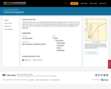
Participants will use a tube and bead (or ball) model to visualize …
Participants will use a tube and bead (or ball) model to visualize and predict how changes in sea level can control the lateral and vertical facies distribution within and adjacent to a marine sedimentary basin. They will also critique the model and identify shortcomings and assumptions involved in the model. Participants will use their knowledge to draw a sea-level curve for Paleozoic rocks of the Central Midwest.
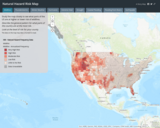
Interactive Risk Map that shows the amount of risk associated with different …
Interactive Risk Map that shows the amount of risk associated with different Natural Hazards for each area of the United States. These natural hazards include: Fires, Floods, Earthquakes, Thunderstorms / Tornadoes, Droughts, Hurricanes, Winter Weather events, Extreme heat.
In this unit, students will explore how global climate change impacts marine …
In this unit, students will explore how global climate change impacts marine ecosystems (especially kelp forests and coral reefs) and the survival and migration patterns of species within marine ecosystems. Students will examine how marine resources and fisheries upon which humans depend (especially marginalized and vulnerable human populations) are being affected by ocean warming and what we can learn from Indigenous peoples on how to mitigate the effects of ocean warming. Lastly, students will learn about innovative solutions to addressing the impacts of ocean warming and propose their own solution to the problem.
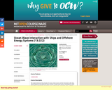
Introduces the physics and mathematical modeling of linear and nonlinear surface wave …
Introduces the physics and mathematical modeling of linear and nonlinear surface wave interactions with floating bodies, e.g., ships and offshore platforms. Surface wave theory, including linear and nonlinear effects in a deterministic and random environment. Ship Kelvin wave pattern and wave resistance. Theory of linear surface wave interactions with floating bodies. Drift forces. Forward speed effects. Ship motions and wave-induced structural loads.
In this activity, students learn about ocean currents and the difference between …
In this activity, students learn about ocean currents and the difference between salt and fresh water. They use colored ice cubes to see how cold and warm water mix and how this mixing causes currents. Also, students learn how surface currents occur due to wind streams. Lastly, they learn how fresh water floats on top of salt water, the difference between water in the ocean and fresh water throughout the planet, and how engineers are involved in the design of ocean water systems for human use.
This class examines tools, data, and ideas related to past climate changes …
This class examines tools, data, and ideas related to past climate changes as seen in marine, ice core, and continental records. The most recent climate changes (mainly the past 500,000 years, ranging up to about 2 million years ago) will be emphasized. Quantitative tools for the examination of paleoceanographic data will be introduced (statistics, factor analysis, time series analysis, simple climatology).
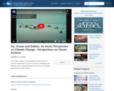
Join Scripps Institution of OceanographyŐs Robert Pinkel as he provides a window …
Join Scripps Institution of OceanographyŐs Robert Pinkel as he provides a window into the cold world of Arctic oceanography and illustrates how the interplay between sea ice and ocean circulation impacts Earth's climate. (51 minutes)
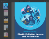
This lesson plan encourages students to think about the effects of pollution …
This lesson plan encourages students to think about the effects of pollution on marine life. Students will also brainstorm solutions to a real-world problem and create an action plan.
This course introduces theoretical and practical principles of design of oceanographic sensor …
This course introduces theoretical and practical principles of design of oceanographic sensor systems. Topics include: transducer characteristics for acoustic, current, temperature, pressure, electric, magnetic, gravity, salinity, velocity, heat flow, and optical devices; limitations on these devices imposed by ocean environments; signal conditioning and recording; noise, sensitivity, and sampling limitations; and standards. Lectures by experts cover the principles of state-of-the-art systems being used in physical oceanography, geophysics, submersibles, acoustics. For lab work, day cruises in local waters allow students to prepare, deploy and analyze observations from standard oceanographic instruments.
Examines the intellectual foundations of the new discipline of deep sea archaeology, …
Examines the intellectual foundations of the new discipline of deep sea archaeology, a convergence of oceanography, archaeology, and engineering. How best are robots and submarines employed for archaeological work? How do new technologies change operations plans, research designs, and archaeological questions? Covers oceanography, history and technology of underwater vehicles, search strategies, technology development, archaeological technique, sociology of scientific knowledge. Case studies of deep-sea projects include the wrecks of the Titanic and Monitor, Roman trading vessels in the Mediterranean, and deep research in the Black Sea.
Changing ocean chemistry could have a disastrous impact on shellfish and fisheries …
Changing ocean chemistry could have a disastrous impact on shellfish and fisheries in Puget Sound. The Suquamish Tribe is working with partners to inform the public about this problem while they elicit support for research and monitoring the issue.
Students use a table-top-sized tsunami generator to observe the formation and devastation …
Students use a table-top-sized tsunami generator to observe the formation and devastation of a tsunami. They see how a tsunami moves across the ocean and what happens when it reaches the continental shelf. Students make villages of model houses and buildings to test how different material types are impacted by the huge waves. They further discuss how engineers design buildings to survive tsunamis. Much of this activity setup is the same as for the Mini-Landscape activity in Lesson 4 of the Natural Disasters unit.
This is a 3 part lesson plan about the fishing industry and …
This is a 3 part lesson plan about the fishing industry and ocean populations. Students will first model through a simulation how fishing affects ocean animal populations. Then students will create and design solutions to the issue of overfishing. Then students will learn about how to support sustainability with the fishing industry and how to find businesses that practice sustainable fishing practices. This lesson is connected to the science and engineering practices and next generation science standards.
This NASA animation depicts thermohaline circulation in the ocean and how it …
This NASA animation depicts thermohaline circulation in the ocean and how it relates to salinity and water density. It illustrates the sinking of water in the cold, dense ocean near Iceland and Greenland. The surface of the ocean then fades away and the animation pulls back to show the global thermohaline circulation system.
This is a hands on activity where students will see how instruments …
This is a hands on activity where students will see how instruments can be used to warn people of a tsunami. This activity demonstration can be flexible to the needs and ages of the students and can be a game or a conversation.
Wake is a science game that challenges students with engaging and authentic …
Wake is a science game that challenges students with engaging and authentic missions in a variety of ocean-based ecosystems, designed to target the NGSS science practices of experimentation, modeling, and argumentation, in the context of middle school life sciences.
In the game, students take the role of a scientist studying ocean ecosystems, traveling to different ocean research sites to answer questions and solve problems. Students play the game at their own pace, working individually, and taking on gradually more complex science challenges in an open-ended environment.
Check out the Teacher Support Site for curriculum ideas and resources: https://sites.google.com/wisc.edu/waketeacherguide/home
No restrictions on your remixing, redistributing, or making derivative works. Give credit to the author, as required.
Your remixing, redistributing, or making derivatives works comes with some restrictions, including how it is shared.
Your redistributing comes with some restrictions. Do not remix or make derivative works.
Most restrictive license type. Prohibits most uses, sharing, and any changes.
Copyrighted materials, available under Fair Use and the TEACH Act for US-based educators, or other custom arrangements. Go to the resource provider to see their individual restrictions.