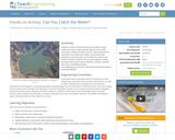
Students construct three-dimensional models of water catchment basins using everyday objects to …
Students construct three-dimensional models of water catchment basins using everyday objects to form hills, mountains, valleys and water sources. They experiment to see where rain travels and collects, and survey water pathways to see how they can be altered by natural and human activities. Students discuss how engineers design structures that impact water collection, as well as systems that clean and distribute water.
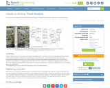
Students learn how to use and graph real-world stream gage data to …
Students learn how to use and graph real-world stream gage data to create event and annual hydrographs and calculate flood frequency statistics. Using an Excel spreadsheet of real-world event, annual and peak streamflow data, they manipulate the data (converting units, sorting, ranking, plotting), solve problems using equations, and calculate return periods and probabilities. Prompted by worksheet questions, they analyze the runoff data as engineers would. Students learn how hydrographs help engineers make decisions and recommendations to community stakeholders concerning water resources and flooding.
This short lesson plan explains what a watershed is and their significance. …
This short lesson plan explains what a watershed is and their significance. Included is a student handout and ideas for extension with community service.
In a class demonstration, students observe a simple water cycle model to …
In a class demonstration, students observe a simple water cycle model to better understand its role in pollutant transport. This activity shows one way in which pollution is affected by the water cycle; it simulates a point source of pollution in a lake and the resulting environmental consequences.
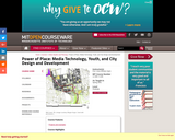
This workshop provides an introduction to urban environmental design and explores the …
This workshop provides an introduction to urban environmental design and explores the potential of information technology and the Internet to transform public education, city design, and community development in inner-city neighborhoods. Integration of comprehensive ("top-down") and grassroots ("bottom-up") approaches to design and planning is a major theme.
This lesson uses Dr. Gholdy Muhammad's Historically Responsive Literacy Framework to develop …
This lesson uses Dr. Gholdy Muhammad's Historically Responsive Literacy Framework to develop a lesson about water protectors that uses the Wisconsin Environmental Education Standards (ELS) for middle school students.
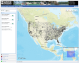
The National Water Information System (NWIS) Mapper provides access to over 1.5 …
The National Water Information System (NWIS) Mapper provides access to over 1.5 million sites contained in the USGS National Water Information System (NWIS), including sites where current and historical surface-water, groundwater, springs, and atmospheric data has been collected. Users can search by site type, data type, site number, or place.
Students learn about the water cycle and its key components. First, they …
Students learn about the water cycle and its key components. First, they learn about the concept of a watershed and why it is important in the context of engineering hydrology. Then they learn how we can use the theory of conservation of mass to estimate the amount of water that enters a watershed (precipitation, groundwater flowing in) and exits a watershed (evaporation, runoff, groundwater out). Finally, students learn about runoff and how we visualize runoff in the form of hydrographs.
This series of 5 high-quality, standards-aligned, inquiry-based lessons have been field-tested by …
This series of 5 high-quality, standards-aligned, inquiry-based lessons have been field-tested by the fifth grade students of Wequiock Children's Center for Environmental Science and their teachers. These lessons encourage students to use natural areas around their school as they improve their science and engineering skills as part of a unit on earth's systems. Created as a part of a WISELearn OER Innovation project, Connect, Explore, and Engage: Using the Environment as the Context for Science Learning was a collaboration of the Wequiock Children's Center for Environmental Science and the Wisconsin Green Schools Network. One of the goals of the project was to create standards-aligned lessons that utilize the outdoor spaces of the school . These lessons were created to take place during late winter. A stewardship project to reduce the impact of stormwater run-off was planned for the spring.
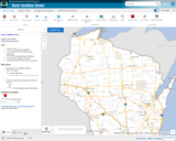
The Water Condition Viewer (WCV) is an interactive mapping tool that focuses …
The Water Condition Viewer (WCV) is an interactive mapping tool that focuses on water condition, monitoring, assessment and management data. Data includes Clean Water Act, Monitoring Projects, Healthy Watersheds Assessments, Targeted Watershed Assessments, Wastewater Evaluation, Watershed Planning, County Land and Water Plans, Nine Key Element Plans and more. All datasets from specialized themes are available from this main, general set of layers.
No restrictions on your remixing, redistributing, or making derivative works. Give credit to the author, as required.
Your remixing, redistributing, or making derivatives works comes with some restrictions, including how it is shared.
Your redistributing comes with some restrictions. Do not remix or make derivative works.
Most restrictive license type. Prohibits most uses, sharing, and any changes.
Copyrighted materials, available under Fair Use and the TEACH Act for US-based educators, or other custom arrangements. Go to the resource provider to see their individual restrictions.