GeoGuessr is a web-based geographic discovery game designed by Anton Wallén, a …
GeoGuessr is a web-based geographic discovery game designed by Anton Wallén, a Swedish consultant, released on 9 May 9, 20. The game uses a semi-randomized Google Street View location and requires players to guess their location in the world using only the clues visible. The website received hundreds of thousands of unique visitors per day within a week of being released.
When we think of international affairs, we often think of the United …
When we think of international affairs, we often think of the United Nations, foreign wars, and world trade summits. Though the geography of international affairs is certainly comprised of these and other such elements, each of these has a historical antecedent and a theoretical frame. In order to understand the realm of international affairs in its contemporary context, it is necessary to understand how we got here. One fundamental part of this is understanding how our global political system came to be and how contemporary systems are based on past iterations. The other fundamental part is to understand the theories that shaped these developments insofar as their influence on global political systems. In this course, we will examine the global political system as it is, as it was, and as it might be in the future.
Geography 431 is designed to further understanding of the natural processes of …
Geography 431 is designed to further understanding of the natural processes of aquatic ecosystems, management of water resources, and threats to sustaining water quantity and quality for all types of freshwater surface, ground, rivers, lakes, wetlands for geographers, ecologists, earth scientists, engineers, planners, other environmental professionals as well as those in non-science fields. This course will develop awareness and appreciation of the multiple perspectives about water as a precious resource, commodity, and sometimes hazard. We will learn how and why water is distributed unevenly in space and time around the Earth. We will examine the ways in which resource management decisions made in human society are strongly related to the availability, quantity, and quality of water. The course examines water resources management, including issues surrounding irrigation; dams and dam removal; provision of safe potable water; threats to water quantity and quality including human and aquatic ecosystem effects; land use changes; the water economy including bottled water, privatization, and water as a free good; water laws and policy; institutions for water management at the global, national, regional, and local scale; and issues of water security and climate change.
The course provides the geospatial information system professional an overview of systems …
The course provides the geospatial information system professional an overview of systems analysis and design with emphasis the concepts behind the design process including: business use case modeling, business object modeling, requirements definition, analysis and preliminary design, and, finally, detailed design and deployment. The concepts of the geospatial software and database development process are introduced and the limitations of current modeling techniques are addressed within the spatial systems development paradigm. In a series of related activities the student applies the methods, tools and the concepts of the systems development process to document a portion of a geospatial system with Unified Modeling Language (UML), the standard graphical notation for modeling application needs. UML affords a common unifying framework that integrates database models with the rest of a system design.
" This course gives an introduction to German language and culture. The …
" This course gives an introduction to German language and culture. The focus is on acquisition of vocabulary and grammatical concepts through active communication. Audio, video, and printed materials provide direct exposure to authentic German language and culture. A self-paced language lab program is fully coordinated with the textbook/workbook. The first semester covers the development of effective basic communication skills."
This is a two-part interactive game for middle school students that introduces …
This is a two-part interactive game for middle school students that introduces them to the concepts of globalization and interdependence. In the first part, the students discover how clothing is sourced globally. The second part describes the issues related to the pieces and parts of a MP3 planner (this part is a little dated, but I have been able to connect it back to cell phones).
Games can be played as a group with the utilization of a Smartboard type device.
The resources includes an educator guide and integration with Google Classroom. I have used it as part of a larger lesson segment in Business Exploratory on Corporate Social Responsibility and Globalization.
"In this lesson, students will learn the basic vocabulary of maps and …
"In this lesson, students will learn the basic vocabulary of maps and the concepts of map projections and distortion. In exploring the Mercator and Peters' map projections, students will learn how looking at different projections can influence our thinking about the world."
Students create a travel brochure enticing others to visit a time and …
Students create a travel brochure enticing others to visit a time and place in history, sharing information about the things one will see and do while they are there.
Spreadsheets Across the Curriculum module. Students use Polya's problem-solving heuristic to find …
Spreadsheets Across the Curriculum module. Students use Polya's problem-solving heuristic to find the distance of a peak using vertical angles sighted from a wagon train heading toward the peak.
This course is an introduction to the consideration of technology as the …
This course is an introduction to the consideration of technology as the outcome of particular technical, historical, cultural, and political efforts, especially in the United States during the 19th and 20th centuries. Topics include industrialization of production and consumption, development of engineering professions, the emergence of management and its role in shaping technological forms, the technological construction of gender roles, and the relationship between humans and machines.
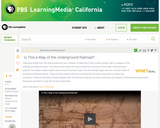
In this segment from History Detectives, Anne Zorela, a map collector, believes …
In this segment from History Detectives, Anne Zorela, a map collector, believes she's found a map that outlines the routes of the Underground Railroad.
Students learn about landslides, discovering that there are different types of landslides …
Students learn about landslides, discovering that there are different types of landslides that occur at different speeds from very slow to very quick. All landslides are the result of gravity, friction and the materials involved. Both natural and human-made factors contribute to landslides. Students learn what makes landslides dangerous and what engineers are doing to prevent and avoid landslides.
This online textbook represents materials that were used in the first four …
This online textbook represents materials that were used in the first four semesters (two years) of the Mandarin program at MIT. They eventually formed the basis of a print textbook of the same name, published by Yale University Press; information and supplemental materials for the Yale edition are available at the companion website. The OCW course materials were extensively revised, and at times reordered, before publication, but the general principles of the original remain: to provide a comprehensive resource for the foundation levels of Chinese language that separates the learning of oral skills from literary (the former being transcribed in pinyin, and the latter in characters). This resource contains the complete online version of the text and accompanying audio recordings.
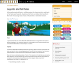
Legends and tall tales are stories filled with unbelievable events or exaggerations …
Legends and tall tales are stories filled with unbelievable events or exaggerations that explain a person’s character or how something came to be. In this project, students will write and produce their own animated tall tale about a historical figure or location.
This course is a friendly introduction to Geographic Information Science and related …
This course is a friendly introduction to Geographic Information Science and related Technologies, reflecting current state-of-the-art and practice. GIScience is the intersection of professions, institutions, and technologies that produce geographic data and render information from it. It is a rapidly growing and evolving field. Learning is a way of life for everyone who is successful in todays every changing world. With this in mind, we hope that this text may contribute to your lifelong exploration of how geographic information and related technologies that generate it can be used to improve the quality of life--yours and your neighbors', locally and globally, now and in the future.
The teacher will set up a skype session with a classroom from …
The teacher will set up a skype session with a classroom from around the world and will not tell the students where the classroom is from. The students will then participate in the skype session in which they will ask yes/no questions. The goal is to be the first class to guess where the other students are from. After the game is finished the students can share about their school and/or culture.
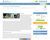
Students are introduced to our planet's structure and its dynamic system of …
Students are introduced to our planet's structure and its dynamic system of natural forces through an examination of the natural hazards of earthquakes, volcanoes, landslides, tsunamis, floods and tornados, as well as avalanches, fires, hurricanes and thunderstorms. They see how these natural events become disasters when they impact people, and how engineers help to make people safe from them. Students begin by learning about the structure of the Earth; they create clay models showing the Earth's layers, see a continental drift demo, calculate drift over time, and make fault models. They learn how earthquakes happen; they investigate the integrity of structural designs using model seismographs. Using toothpicks and mini-marshmallows, they create and test structures in a simulated earthquake on a tray of Jell-O. Students learn about the causes, composition and types of volcanoes, and watch and measure a class mock eruption demo, observing the phases that change a mountain's shape. Students learn that the different types of landslides are all are the result of gravity, friction and the materials involved. Using a small-scale model of a debris chute, they explore how landslides start in response to variables in material, slope and water content. Students learn about tsunamis, discovering what causes them and makes them so dangerous. Using a table-top-sized tsunami generator, they test how model structures of different material types fare in devastating waves. Students learn about the causes of floods, their benefits and potential for disaster. Using riverbed models made of clay in baking pans, students simulate the impact of different river volumes, floodplain terrain and levee designs in experimental trials. They learn about the basic characteristics, damage and occurrence of tornadoes, examining them closely by creating water vortices in soda bottles. They complete mock engineering analyses of tornado damage, analyze and graph US tornado damage data, and draw and present structure designs intended to withstand high winds.
No restrictions on your remixing, redistributing, or making derivative works. Give credit to the author, as required.
Your remixing, redistributing, or making derivatives works comes with some restrictions, including how it is shared.
Your redistributing comes with some restrictions. Do not remix or make derivative works.
Most restrictive license type. Prohibits most uses, sharing, and any changes.
Copyrighted materials, available under Fair Use and the TEACH Act for US-based educators, or other custom arrangements. Go to the resource provider to see their individual restrictions.