Updating search results...

Search Resources

16 Results

View
Selected filters:
  • glaciers
The Environment of the Earth's Surface
Conditional Remix & Share Permitted
CC BY-NC-SA
Rating
0.0 stars

A great variety of processes affect the surface of the Earth. Topics to be covered are production and movement of surficial materials; soils and soil erosion; precipitation; streams and lakes; groundwater flow; glaciers and their deposits. The course combines aspects of geology, climatology, hydrology, and soil science to present a coherent introduction to the surface of the Earth, with emphasis on both fundamental concepts and practical applications, as a basis for understanding and intelligent management of the Earth's physical and chemical environment.

Subject:
Earth and Space Science
Geology
Hydrology
Material Type:
Full Course
Provider:
MIT
Provider Set:
MIT OpenCourseWare
Author:
John Southard
Date Added:
01/02/2011
Field Activity:  Exploring Glaciers, Ancient Seas, and Volcanism
Conditional Remix & Share Permitted
CC BY-NC-SA
Rating
0.0 stars

In a field investigation to Interstate State Park, students determine lava flow boundaries and observe an ancient rift valley. They also examine differential erosion rates that create a waterfall, and examine the local basalts for evidence of glaciation, including the world-famous potholes.

Subject:
Earth and Space Science
Geology
Material Type:
Activity/Lab
Provider:
Science Education Resource Center (SERC) at Carleton College
Provider Set:
Pedagogy in Action
Author:
Ann Berg
Date Added:
02/10/2023
Geodynamics Seminar, Spring 2006
Conditional Remix & Share Permitted
CC BY-NC-SA
Rating
0.0 stars

In this year's Geodynamics Seminar, we will explore the depth and breadth of scientific research related to Earth's present and past ice-sheets, glaciers and sea-ice, as well as extraterrestrial planetary ice. Invited speakers have been chosen from experts in the current frontiers in ice-related research, including planetary ice, climate records from polar and tropical ice cores, the Snowball Earth, subglacial volcanoes, ice rheology, ice sheet modeling, ice microkinetics, glacial erosion and tectonics, subglacial life and polar remote sensing. A field trip to Iceland in Summer 2006 will allow us to view some of the island's ice caps and glacial geology, the exposed mid Atlantic Ridge and evidence of ice-volcano interactions.

Subject:
Earth and Space Science
Geology
Material Type:
Full Course
Provider:
M.I.T.
Provider Set:
M.I.T. OpenCourseWare
Author:
Bice, Karen
Date Added:
01/01/2006
Glaciers:  Then and Now
Restricted Use
Copyright Restricted
Rating
0.0 stars

Explain what glaciers are, how glaciers grow and retreat, and the two types of glaciers: continental and valley (or alpine) glaciers. Discuss the climate conditions that are necessary for a glacier to grow (snowy winters and cool summers). Discuss the climate conditions that are necessary for a glacier to shrink (warmer).

Subject:
Earth and Space Science
Geology
Material Type:
Learning Task
Lesson Plan
Reference Material
Provider:
Windows to The Universe
Date Added:
12/15/2016
Glaciers in Our Own Backyard
Conditional Remix & Share Permitted
CC BY-NC-SA
Rating
0.0 stars

This activity is a 3-day leasson that involves classroom discussion and field exploration of glacial activity in a school forest.

Subject:
Earth and Space Science
Geology
Material Type:
Activity/Lab
Provider:
Science Education Resource Center (SERC) at Carleton College
Provider Set:
Pedagogy in Action
Author:
Rob Marohn
Date Added:
02/10/2023
Going Out on a Limb-Plant Communities of Wisconsin Central Sand Plains
Conditional Remix & Share Permitted
CC BY-NC
Rating
0.0 stars

Through a study of the Central Sand Plains region of Wisconsin, students will participate in learning experiences both in the classroom and outdoors, so that they can recognize and identify natural divisions and forest types within this region. Students will learn how the conditions essential for a native forest community can help us make decisions about what foods grow best in our region. They will write a research piece to compare and contrast the life cycles and structures of two plants, one forest and one garden plant) we have studied.

Subject:
English Language Arts
Environmental Literacy and Sustainability
Material Type:
Unit of Study
Date Added:
02/22/2019
Ice Cream Model -- How Glaciers Formed the Minnesota Landscape
Conditional Remix & Share Permitted
CC BY-NC-SA
Rating
0.0 stars

This activity is a teacher demonstration of an ice cream model representing glacier movement across Minnesota. Teacher/student questions and discussion should be encouraged during the demonstration.

Subject:
Earth and Space Science
Geology
Material Type:
Activity/Lab
Simulation
Provider:
Science Education Resource Center (SERC) at Carleton College
Provider Set:
Pedagogy in Action
Author:
Ginger Baldwin
Date Added:
02/10/2023
Investigating Topography Caused by Glacial Lake Agassiz and Glacial River Warren in the Big Stone Lake area
Conditional Remix & Share Permitted
CC BY-NC-SA
Rating
0.0 stars

This activity is a field investigation where students will observe the topography of Big Stone Lake and generate questions about the history of this area.

Subject:
Earth and Space Science
Geology
Material Type:
Activity/Lab
Provider:
Science Education Resource Center (SERC) at Carleton College
Provider Set:
Pedagogy in Action
Author:
Tracey Raguse
Date Added:
02/10/2023
Investigating the Minnesota River's Glacial History Near Henderson, MN
Conditional Remix & Share Permitted
CC BY-NC-SA
Rating
0.0 stars

This activity is a field investigation where students make observations in the Minnesota River valley, discuss their findings amongst other student groups, and describe how those observations fit with the general geology of Minnesota.

Subject:
Ecology
Life Science
Material Type:
Activity/Lab
Provider:
Science Education Resource Center (SERC) at Carleton College
Provider Set:
Pedagogy in Action
Author:
Brian Allison
Date Added:
02/10/2023
Late Wisconsin Glaciation - Geology ArcGIS Web Application
Conditional Remix & Share Permitted
CC BY-NC
Rating
0.0 stars

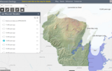
This arc GIS application interactive layer shows the stages of glacial ice locations across Wisconsin from 32,000 to 11,000 years before present. Shows subsequent impacts of glacial activity to form moraines, eskers, kames, and other glacial features including glacial melting to form glacial lakes and features across Wisconsin.

Subject:
Agriculture, Food and Natural Resources
Career and Technical Education
Earth and Space Science
Geology
Material Type:
Activity/Lab
Homework/Assignment
Author:
Jeff Dumez
Date Added:
03/12/2024
Laurentide Ice Sheet: Ice-Margin Positions in Wisconsin (2nd edition)
Unrestricted Use
CC BY
Rating
0.0 stars

Series of 43 page-size maps showing the chronology of the last glaciation's advances and retreats across Wisconsin. Includes a brief discussion about how the maps were made, how lake positions were determined, as well as a list of selected references.

Subject:
Earth and Space Science
Environmental Science
Forestry and Agriculture
Geology
Hydrology
Life Science
Material Type:
Data Set
Diagram/Illustration
Author:
D.M.; Attig
J.W.;
Mickelson
Date Added:
02/20/2024
Mapping the Glaciers
Conditional Remix & Share Permitted
CC BY-NC-SA
Rating
0.0 stars

This earth systems field lab begins with an in-class guided inquiry experience which uses Minnesota Geological Survey 3-D maps of the upper Midwest to determine where they believe glaciers may have had an influence. They will determine this by looking at landscapes and compiling their own evidence from the maps. They will also offer evidence for a hypothesis they generate which involves the direction that the glacier was traveling.

Subject:
Earth and Space Science
Geology
Material Type:
Activity/Lab
Provider:
Science Education Resource Center (SERC) at Carleton College
Provider Set:
Pedagogy in Action
Author:
Cathy Oates-Bockenstedt
Date Added:
02/10/2023
Sinking Water: A Connection With Glaciers, Ocean Currents and Weather Patterns
Conditional Remix & Share Permitted
CC BY-NC-SA
Rating
0.0 stars

This lesson has activities where students will learn about buoyancy and explore how hot water rises and cold water sinks. As an extension and real-life application, students will see that glacial run-off is occurring at a rapid pace and the cold glacial water could potentially change ocean currents thus influencing global climates.

Subject:
Atmospheric Science
Earth and Space Science
Material Type:
Activity/Lab
Provider:
Science Education Resource Center (SERC) at Carleton College
Provider Set:
Pedagogy in Action
Author:
Stanley Mraz
Date Added:
02/10/2023
Special Topics in Earth, Atmospheric, and Planetary Sciences: The Environment of the Earth's Surface, Spring 2007
Conditional Remix & Share Permitted
CC BY-NC-SA
Rating
0.0 stars

" A great variety of processes affect the surface of the Earth. Topics to be covered are production and movement of surficial materials; soils and soil erosion; precipitation; streams and lakes; groundwater flow; glaciers and their deposits. The course combines aspects of geology, climatology, hydrology, and soil science to present a coherent introduction to the surface of the Earth, with emphasis on both fundamental concepts and practical applications, as a basis for understanding and intelligent management of the Earth's physical and chemical environment."

Subject:
Earth and Space Science
Geology
Hydrology
Material Type:
Full Course
Provider:
M.I.T.
Provider Set:
M.I.T. OpenCourseWare
Author:
Southard, John
Date Added:
01/02/2011
Student Created Landform Maps with Glacial Emphasis
Conditional Remix & Share Permitted
CC BY-NC-SA
Rating
0.0 stars

Students learn glacial landforms and create a landform map including a location grid (eg. position A2) and map key.

Subject:
Earth and Space Science
Geology
Material Type:
Activity/Lab
Lesson Plan
Provider:
Science Education Resource Center (SERC) at Carleton College
Provider Set:
Pedagogy in Action
Author:
Carlyn Wilson
Date Added:
02/10/2023
WGNHS – Wisconsin Geological and Natural History Survey – UW–Madison
Only Sharing Permitted
CC BY-NC-ND
Rating
0.0 stars

The Wisconsin Geological and Natural History Survey (WGNHS) has been serving Wisconsin for over 125 years. Part of the Division of Extension at the University of Wisconsin–Madison, WGNHS provides objective scientific information about the geology, mineral resources, and water resources of Wisconsin. We conduct research, map Wisconsin’s geology, and share information through our publications and outreach.

WGNHS has been producing geologic maps, scientific reports, and more for over 125 years. Our publications catalog offers thousands of maps, reports, datasets, and other publications—all of which are available to view and download for free.

The Wisconsin Geological and Natural History Survey (WGNHS) was created by the Wisconsin Legislature in 1897. It is the descendant of earlier state surveys in Wisconsin, which date back to 1854.

WGNHS, part of the Division of Extension at the University of Wisconsin–Madison, is an interdisciplinary organization that conducts natural resources surveys and research to produce information used for decision-making, problem-solving, planning, management, development, and education. Survey is defined to include resource inventory as well as basic and applied research and analysis. WGNHS has no specific regulatory or enforcement responsibilities.

Mission of WGNHS:
Understanding the earth • Charting its history • Sustaining its resources
The Survey conducts earth-science surveys, field studies, and research.

We provide objective scientific information about the geology, water resources, and mineral resources of Wisconsin.

We collect, interpret, disseminate, and archive natural resource information.

We communicate the results of our activities through publications, technical talks, our website, social media, and responses to inquiries from the public.

These activities support informed decision making by government, industry, business, and individual residents of Wisconsin.
Subject:
Agriculture, Food and Natural Resources
Archaeology
Biology
Botany
Career and Technical Education
Civics and Government
Earth and Space Science
Ecology
Education
Environmental Science
Forestry and Agriculture
Geography
Geology
Higher Education
Hydrology
Life Science
Social Studies
Material Type:
Activity/Lab
Diagram/Illustration
Homework/Assignment
Other
Date Added:
03/04/2024