Establishes basic attitudes toward architectural organization and its reflection in form. Includes …
Establishes basic attitudes toward architectural organization and its reflection in form. Includes projects where imposed conditions of site, program, and building system emphasize the interrelationship of fundamental elements in the pattern of decision-making that constitutes architectural design. Develops presentations through drawings and models. Intended for entering M.Arch. students. Course Description This studio explores the notion of in-between by engaging several relationships; the relationship between intervention and perception, between representation and notation and between the fixed and the temporal. In the Exactitude in Science, Jorge Luis Borges tells the perverse tale of the one to one scale map, where the desire for precision and power leads to the escalating production of larger and more accurate maps of the territory. For Jean Baudrillard, "The territory no longer precedes the map nor survives it. ĺÉit is the map that precedes the territory... and thus, it would be the territory whose shreds are slowly rotting across the map." The map or the territory, left to ruin-shredding across the 'other', beautifully captures the tension between reality and representation. Mediating between collective desire and territorial surface, maps filter, create, frame, scale, orient, and project. A map has agency. It is not merely representational but operational, the experience and discursive potential of this process lies in the reciprocity between the representation and the real. It is in-between these specific sets of relationships that this studio positions itself.
To manage their businesses successfully, farmers and food production companies need to …
To manage their businesses successfully, farmers and food production companies need to know what crops are in the ground and how well they are growing. A pair of easy-to-use online mapping tools provides this information for growing seasons in the past and present.
Students explore the definition of a function by playing an interactive game …
Students explore the definition of a function by playing an interactive game called "Club Function." The goal of the game is to be in the club! With students each assigned to be either a zebra or a rhinoceros, they group themselves according to the "rules" of the club function. After two minutes, students freeze in their groups, and if they are not correctly following the rules of the club function, then they are not allowed into the "club." Through this activity students come to understand that one x-coordinate can only have one corresponding y-coordinate while y-coordinates can have many x-coordinates that correspond to it.
Unit Title: Dream Garden MeasurementsAuthor: Melissa WimmlerSchool: Discovery Charter School, Columbus School …
Unit Title: Dream Garden MeasurementsAuthor: Melissa WimmlerSchool: Discovery Charter School, Columbus School DistrictGrade Level: 2nd GradeContent Area(s): Math, Environmental ScienceContext: Our governance council is working on a school wide project to improve the lawn space in front of our school and create our dream garden. During this six-lesson unit the second-grade students estimated and accurately measured objects in the space and perimeter. The students calculated the area of the space and used square units to plan spaces and garden beds.
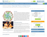
Students use graph theory to create social graphs for their own social …
Students use graph theory to create social graphs for their own social networks and apply what learn to create a graph representing the social dynamics found in a dramatic text. Students then derive meaning based on what they know about the text from the graphs they created. Students learn graph theory vocabulary, as well as engineering applications of graph theory.
Students analyze their social networks using graph theory. They gather data on …
Students analyze their social networks using graph theory. They gather data on their own social relationships, either from Facebook interactions or the interactions they have throughout the course of a day, recording it in Microsoft Excel and using Cytoscape (a free, downloadable application) to generate social network graphs that visually illustrate the key persons (nodes) and connections between them (edges). The nodes in the Cytoscape graphs are color-coded and sized according to the importance of the node (in this activity, nodes are people in students' social networks). After the analysis, the graphs are further examined to see what can be learned from the visual representation. Students gain practice with graph theory vocabulary, including node, edge, betweeness centrality and degree on interaction, and learn about a range of engineering applications of graph theory.
The marine environment is unique and requires technologies that can use sound …
The marine environment is unique and requires technologies that can use sound to gather information since there is little light underwater. The sea-floor is characterized using underwater sound and acoustical systems. Current technological innovations are allowing scientists to further understand and apply information about animal locations and habitat. Remote sensing and exploration with underwater vehicles allows scientists to map and understand the sea floor, and in some cases, the water column. In this lesson, the students will be shown benthic habitat images produced by GIS. These imaged will lead to a class discussion on why habitat mapping is useful and how current technology works to make bathymetry mapping possible. The teacher will then ask inquiry-based questions to have students brainstorm about the importance of bathymetry mapping.
A regional conservation partnership in Massachusetts needed to update their approach to …
A regional conservation partnership in Massachusetts needed to update their approach to evaluating land acquisitions. Adding the complexity of climate change to their map helped resolve their vision.
This outdoor investigation involves students observing, recording, comparing and pondering the differing …
This outdoor investigation involves students observing, recording, comparing and pondering the differing landscapes and rocks located along a river. Follow-up class sessions involve student generation of investigable questions, student-generated studies with required write-up and a mapping activity.
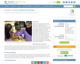
MASLab (Mobile Autonomous System Laboratory) is a robotics contest. The contest takes …
MASLab (Mobile Autonomous System Laboratory) is a robotics contest. The contest takes place during MIT's Independent Activities Period and participants earn 6 units of P/F credit and 6 Engineering Design Points. Teams of three to four students have less than a month to build and program sophisticated robots which must explore an unknown playing field and perform a series of tasks. MASLab provides a significantly more difficult robotics problem than many other university-level robotics contests. Although students know the general size, shape, and color of the floors and walls, the students do not know the exact layout of the playing field. In addition, MASLab robots are completely autonomous, or in other words, the robots operate, calculate, and plan without human intervention. Finally, MASLab is one of the few robotics contests in the country to use a vision based robotics problem.
Our Open Web Mapping course (GEOG 585) teaches students how to publish …
Our Open Web Mapping course (GEOG 585) teaches students how to publish geographic data and maps through the use of open-source web mapping standards and software. Such a solution is best suited for situations that involve the sharing of large datasets (particularly those with line or polygon geometry) or that require a relatively advanced interface. This course teaches how to build mapping applications using two APIs (specifically, the Google Maps API and Esri's JavaScript API). Such applications are often referred to as mashups, because they bring together data from multiple sources to produce a new product. The advantages of building a map application via this route are that background layers are provided by the company who wrote the API and that the learning curve for using the APIs is less steep than learning how to build comparable applications with open web mapping software. By the end of this course, you will be able to build a fairly sophisticated mapping application that would require a lot more effort and cost to replicate through other means.
Projections and coordinates are key advancements in the geographic sciences that allow …
Projections and coordinates are key advancements in the geographic sciences that allow us to better understand the nature of the Earth and how to describe location. These innovations in describing the Earth are the basis for everything that is done in a GIS framework. Shape of the Earth is a critical starting point because in fact the Earth is not round but rather a more complex shape called a geoid. Coordinate systems are often referenced to a particular model shape of the Earth, but many different formats exist because not all coordinates work equally well in all areas. While projections and coordinates are abstract concepts in themselves, students eventually find them interesting because 1) it causes them to challenge their current ideas of the Earth's shape and 2) it is much easier to visualize these ideas for learning through interactive GIS such as Google Earth.
Students learn and practice how to find the perimeter of a polygonal …
Students learn and practice how to find the perimeter of a polygonal shape. Using a ruler, they measure model rooms made of construction paper walls. They learn about other tools, such as a robot, that can help them take measurements. Using a robot built from a LEGO® MINDSTORMS® NXT kit that has been programmed to move along a wall and output the length of that wall, students record measurements and compare the perimeter value found with the robot to the perimeter found using a ruler. In both cases, students sketch maps to the scale of the model room and label the measured lengths. A concluding discussion explores the ways in which using a robot may be advantageous or disadvantageous, and real-world applications.
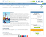
In a simulation of potential future space missions to Europa, one of …
In a simulation of potential future space missions to Europa, one of Jupiter’s moons, student teams are challenged to direct a robot placed in an enclosed maze to search for and find the most “alien life.” The robot is equipped with a camera to send a live feed of its surroundings in the maze. Students control the robot from outside the maze by looking at the live feed on a smartphone and using the robot’s remote control, making a map as they go. The student teams compete as if they are space agencies creating their own exploratory systems to meet the challenge’s criteria and constraints and prove “in the field” that they have the best plan to win the mission contract and get the job. This activity simulates the real-world research of scientists and engineers developing a robot with the capabilities to explore under the ice-covered surface of Europa.
" This class focuses on representation tools used by architects during the …
" This class focuses on representation tools used by architects during the design process and attempts to discuss the relationship they develop with the object of design. Representation plays a key role in architectural design, not only as a medium of conveying and narrating a determined meaning or a preconceived idea, but also as a code of creating new meaning, while the medium seeks to establish a relationship with itself. In this sense, mediums of representation, as external parameters to the design process, are not neutral tools of translating an idea into its concrete form. They are neither authentic means of creativity, nor vapid carriers of an idea. Therefore, an important aspect in issues of meaning is how the architect manipulates the play of translating a concept to its concrete version, through the use of a medium of representation. The course is a continuation of the equivalent course taught in the fall semester and specifically focuses on digital media. The course is intended to establish a reciprocal relationship with the design studio, feeding from and contributing to its content."
Students analyze dramatic works using graph theory. They gather data, record it …
Students analyze dramatic works using graph theory. They gather data, record it in Microsoft Excel and use Cytoscape (a free, downloadable application) to generate graphs that visually illustrate the key characters (nodes) and connections between them (edges). The nodes in the Cytoscape graphs are color-coded and sized according to the importance of the node (in this activity nodes represent characters in the work and their relative importance to the story). After the analysis, the graphs are further examined to see what the visual depiction of the story in the form of a graph tells readers about the inner workings of the dramatic work. Students gain practice with graph theory vocabulary, including node, edge, betweeness centrality and degree on interaction, and learn about a range of engineering applications of graph theory.
This activity is an inquiry based field investigation where students measure and …
This activity is an inquiry based field investigation where students measure and map a small stream and then develop an understanding of the formation of a variety of small stream features.
Geographic information systems (GIS) are important technology that allows rapid study and …
Geographic information systems (GIS) are important technology that allows rapid study and use of spatial information. GIS have become increasingly prevalent in industry and the consumer/internet world in the last 20 years. Historically, the basis of GIS was in mapping, and so it is important to understand the basis of maps and how to use them as well as why they are different from GIS. In this lesson, students learn the value of maps, how to use maps, and the basic components of a GIS. They are also introduced to numerous GIS applications.
In a student-led and fairly independent fashion, data collected in the associated …
In a student-led and fairly independent fashion, data collected in the associated field trip activity are organized by student groups to create useful and informative Google Earth maps. Each team creates a map, uses that map to analyze the results, adjusts the map to include the analysis results, and then writes a brief summary of findings. Primarily, questions of fate-and-transport of plastics are are explored. If data was gathered in the field trip but the teacher does not desire to do the mapping activity, then alternative data presentation and analysis methods are suggested.
No restrictions on your remixing, redistributing, or making derivative works. Give credit to the author, as required.
Your remixing, redistributing, or making derivatives works comes with some restrictions, including how it is shared.
Your redistributing comes with some restrictions. Do not remix or make derivative works.
Most restrictive license type. Prohibits most uses, sharing, and any changes.
Copyrighted materials, available under Fair Use and the TEACH Act for US-based educators, or other custom arrangements. Go to the resource provider to see their individual restrictions.