All resources in Wisconsin-Based Science Storylines Resources

About Climate Wisconsin – Climate Wisconsin – PBS Wisconsin Education

(View Complete Item Description)

Climate Wisconsin is an educational multimedia collection featuring stories about the impact of climate change in Wisconsin. LEARNING GOALS: Expand understanding of how climate change impacts life in Wisconsin. Connect personal observations to the study of climate and environmental science. Identify actions that may impact changes to our climate.

Material Type: Activity/Lab, Diagram/Illustration, Homework/Assignment, Interactive

Author: PBS Wisconsin Education

Wisconsin Lakes Data - Lake Water Quality Data - Lake Maps - Plants and Aquatic Insects

(View Complete Item Description)

Wisconsin's 15,000 lakes. The DNR partners with the University of Wisconsin - Extension and citizens around the state to help protect and maintain these amazing natural resources while providing some of the best recreational opportunities in the nation. More than 600 lake organizations and thousands of volunteers play a leadership role in the stewardship of Wisconsin's lakes. Find a Lake, Lake Water Quality Data, Lake Maps, Plants and Aquatic invasive Insects - are all linked to this site.

Material Type: Activity/Lab, Data Set, Diagram/Illustration, Interactive

Author: Wisconsin Department of Natural Resources

Water Clarity Monitoring - Extension Lakes

(View Complete Item Description)

Water clarity monitoring is a process in which the volunteer lowers an 8” diameter, black & white disc (“Secchi disc”) into the deepest part of the lake to determine how far down they can see the disc as it is lowered. Water clarity monitoring is done every 10-14 days throughout the open-water season. Water clarity is a quick way to estimate lake health, and it plays an important role in determining the types of plants and animals that a water body can support. Can also add in collected data for Water Chemistry analysis along with Secchi disc collected data. This site includes data collection forms for individuals or groups to add their data from their own lake to this dataset.

Material Type: Activity/Lab, Homework/Assignment, Lesson

Authors: college of Natural Resources, Paul Skawinski, University of Wisconsin Stevens Point

Wisconsin Lakes - Water Quality Data for each lake by County

(View Complete Item Description)

Volunteers, DNR staff, county staff and others collect water clarity, temperature and dissolved oxygen, as well as other water quality data, on lakes across Wisconsin. Around 1,000 volunteers are currently active, and the network has been going strong since 1986. Water clarity is measured with a black and white disk called a "Secchi Disk". Satellite images are used to retrieve water clarity data for lakes across the state. This effort began in 1999 when the University of Wisconsin-Madison Environmental Remote Sensing Center (ERSC) developed a model for the retrieval of water clarity data from satellite images and Citizen Lake Monitoring Network volunteers provided on-the-ground Secchi data to calibrate this model for each satellite image. Water clarity data was retrieved for over 8,000 lakes statewide between 1999 and 2001. The DNR continues to analyze data in this way today in its remote sensing program.

Material Type: Data Set, Diagram/Illustration, Other

Author: Wisconsin Department of Natural Resources

PFAS Interactive Data Viewer - Wisconsin Department of Natural Resources

(View Complete Item Description)

The PFAS Interactive Data Viewer is a mapping tool that incorporates datasets from several DNR programs to show locations throughout Wisconsin that have been impacted by PFAS. Information included in the PFAS Interactive Data Viewer include locations with known PFAS contamination and whether clean up has been completed; results from testing municipal drinking water for PFAS; locations with PFAS-related fish and game consumption advisories; and waterbodies throughout Wisconsin sampled for PFAS during targeted or routine monitoring. These data may not reflect current PFAS levels at specific locations.

Material Type: Data Set, Diagram/Illustration, Interactive

Author: Wisconsin Department of Natural Resources

Ice Age Trail in Wisconsin -Interactive map

(View Complete Item Description)

This data layer includes lines representing existing sections of the Ice Age National Scenic Trail. This version of the data is hosted by Wisconsin DNR for DNR staff use and public download and is updated approximately every two months. This layer is hosted by Wisconsin DNR, and reflects Ice Age Trail updates received from the Ice Age Trail Alliance on December 21st, 2023. This layer is typically updated approximately every two months and is primarily for the purpose of DNR staff use and public download from DNR's Open Data Portal. For more current trail data contact Tiffany Stram (tiffany@iceagetrail.org) GIS/Technology Specialist at Ice Age Trail Alliance. For the official depiction of Ice Age Trails in Wisconsin, see Ice Age Trail Alliance's Ice Age National Scenic Trail Existing Sections - Official Layer: https://www.arcgis.com/home/item.html?id=735b25ad50e74520b7396d9168f53cfc. This data layer includes lines representing existing sections of the Ice Age National Scenic Trail. This layer is a combination of GPS and digitized data, merged to represent one complete data layer for the IAT. The data was developed by the Ice Age Trail Alliance (IATA) in cooperation with the National Park Service's Ice Age Trail Office.

Material Type: Data Set, Diagram/Illustration, Interactive, Other, Reference Material

Authors: Wisconsin Department of Natural Resources, Wisconsin DNR Data Curator

Wisconsin's historical Earthquakes - Latest Earthquakes in World - USGS

(View Complete Item Description)

This is a map showing the location and severity of each of the Earthquakes which have occurred in Wisconsin in recorded history. This site is also where one can find recent or historic earthquakes, lists, information on selected significant earthquakes, earthquake resources by state, or find webservices.

Material Type: Activity/Lab, Diagram/Illustration, Homework/Assignment, Lecture

Author: USGS (US Geological Survey)

Wolves in Wisconsin

(View Complete Item Description)

Wisconsin Department of Natural Resources dataset of current Wolf population and distribution of wolf packs found throughout Wisconsin. Following a federal court ruling on Feb. 10, 2022, gray wolves are listed as an endangered species in the lower 48 states (excluding the northern Rocky Mountains region). As such, wolves are federally protected. Harvest and lethal depredation control are prohibited. Wisconsin's wolf population remains healthy and secure in the state. The department will continue its robust wolf population monitoring program and the development of an updated wolf management plan. The DNR will continue to partner with USDA-Wildlife Services to address wolf conflicts in Wisconsin. If you suspect wolves in the depredation of livestock, pets or hunting dogs, or if wolves are exhibiting threatening or dangerous behavior, contact USDA-Wildlife Services staff immediately. If in northern Wisconsin, call 1-800-228-1368 or 715-369-5221; in southern Wisconsin, call 1-800-433-0663 or 920-324-4514. While gray wolves are listed as a federally endangered species, it remains unlawful to shoot a wolf unless there is an immediate threat to human safety.

Material Type: Data Set, Diagram/Illustration, Other, Reference Material

Author: Wisconsin Department of Natural Resources

Wisconsin's Champion Trees

(View Complete Item Description)

The Champion Tree Program recognizes and celebrates the state’s largest trees. The Wisconsin Department of Natural Resources began documenting these trees in 1941 with the help of the community. People around the state discovered these trees in the Northwoods, in neighbors’ yards and along city streets. The program has endured as a result of people such as yourself. We invite you to join us in honoring and preserving Wisconsin’s natural resources heritage.

Material Type: Data Set, Diagram/Illustration, Other, Reference Material

Author: Wisconsin Department of Natural Resources

Black bear population in Wisconsin - status and distribution

(View Complete Item Description)

Wisconsin's occupied bear range is expanding, which means residents can expect to see black bears in areas outside of the bear's traditional range. An abundant population and suitable bear habitat have facilitated the southerly movement of occupied bear range in Wisconsin. Wisconsin's black bear population is considerably higher than it was 30 years ago. Wisconsin's bear population was estimated to be about 9,000 bears in 1989. The most recent data indicates the bear population is currently estimated to be a little over 24,000 bears. DNR manages bear population size through regulated hunting. The number of hunting permits have steadily increased following studies showing higher numbers of bears. In the near future, opportunities will be provided to the public to comment on the desired numbers of bears in each of the state's bear management regions as the DNR prepares a new bear management plan. Wisconsin is not alone in its expanding bear range. The results from a 2008 survey of eastern United States and Canadian Provinces that actively manage black bear populations indicated that 75% of these jurisdictions report an increase in bear range. Only Vermont reported a contracting bear range.

Material Type: Data Set, Diagram/Illustration, Interactive

Author: Wisconsin Department of Natural Resources

Snapshot Wisconsin Data Dashboard

(View Complete Item Description)

Snapshot Wisconsin is a partnership to monitor wildlife year-round, using a statewide network of trail cameras. Snapshot Wisconsin provides data needed for decision making at the Wisconsin Department of Natural Resources. It is also a unique opportunity for individuals, families, and students to get involved in monitoring the state’s valuable natural resources. This tool is designed to help visualize many aspects of Snapshot Wisconsin data.

Material Type: Data Set, Interactive, Other, Reference Material

Authors: SnapShot Wisconsin, Wildlife Restoration, Wisconsin Department of Natural Resources

Elk in Wisconsin

(View Complete Item Description)

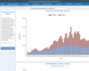
Once widespread here and across North America, elk were eliminated from Wisconsin in the 1880s due to unregulated hunting and habitat loss. Over 130 years later, they once again live in our state's central and northern forest regions. From a population of 25 elk reintroduced in 1995, and with the help of the second reintroduction effort that started in 2015, the state's total elk population has now surpassed 400 animals. Thanks to the support of multiple partners and the backing of Wisconsin citizens, the bugle of rutting September bulls is back and here to stay! Elk (Cervus canadensis) is one of North America's most significant deer family members (Cervidae), second only to moose. Wisconsin's native elk (before European settlement) belonged to the Eastern elk subspecies (C. c. canadensis), believed to have gone extinct during the late 1800s. The Rocky Mountain sub-species (C. c. nelsoni) was later used in reintroduction efforts in Wisconsin and other eastern U.S. states. Elk is one of three members of the deer family that lives in Wisconsin regularly, with the other two being white-tailed deer (Odocoileus virginianus) and moose (Alces alces). Elk are approximately three times larger than deer and about two-thirds the size of moose. Adult elk are light tan-colored with a darker mane on their neck with a distinct buff-colored rump patch and stub tail. Elk vary in size by sex. A mature cow stands approximately four and a half feet tall at the shoulder, six and a half feet in length from nose to tail and weighs 500-650 pounds. In contrast, a mature bull may stand five feet or more at the shoulder, stretch over eight feet long and weigh 600-900 pounds. Wisconsin elk calves typically weigh between 35-40 pounds at birth. Calves are born with white spots to help them blend into their surroundings during their first few months. Elk are also a herd-associated species that have many vocalizations and unique characteristics.

Material Type: Data Set, Interactive

Author: Wisconsin Department of Natural Resources

Wisconsin's Fishes

(View Complete Item Description)

Do you know your Wisconsin fish? Wisconsin is home to more than 160 different fish species. The fish species below are most commonly caught by Wisconsin anglers. Also links to these resources: Wisconsin's state record fish Hooked on Wisconsin Anglers' Club Game fish of Wisconsin poster Fish Wildcards - A set of 45 fish, plus games, knots, basic fish anatomy, a common fish parasite, and a handy trick to estimate your fish’s weight with a ruler! Two versions: Match Your Catch, Low-Res Version [PDF] or Match Your Catch, Hi-Res Version [PDF] Fish of Wisconsin [exit DNR] Fish identification database [exit DNR] Burbot, bowfin and snakehead identification Wisconsin fish species list [PDF] - a printable document with Wisconsin's fish species.

Material Type: Activity/Lab, Data Set, Interactive, Reference Material

Author: Wisconsin Department of Natural Resources

Protecting Wisconsin's Biodiversity

(View Complete Item Description)

Biodiversity is a shortened form of the term "biological diversity." The entire spectrum of life forms and the many ecological processes support them. Wisconsin is blessed with abundant biodiversity. Located at the junction of the eastern deciduous forest, northern boreal forest and temperate grasslands, we have a wealth of species and natural communities. Approximately 1,800 species of native plants and close to 700 species of native vertebrates have been identified in Wisconsin. In addition, there are thousands of species of non-vascular plants and invertebrates. These pages highlight the uncommon and rare species, natural communities, geological features and essential habitat areas throughout Wisconsin.

Material Type: Activity/Lab, Data Set, Interactive

Author: Wisconsin Department of Natural Resources

Wisconsin's record fish program

(View Complete Item Description)

Fishing in Wisconsin's waters is enjoyed by many, but only a few anglers apply their skills to the extent that they catch a verified record fish. The Wisconsin Department of Natural Resources (DNR) recognizes anglers who have legally taken the largest fish on record by hook and line and those fish that have been taken by alternate methods (for example, spearing or bow fishing). Live release record fish category Hook and line records Alternate method records (spear, bow and arrow, crossbow) The DNR does not keep line-class or lake-specific records. However, you may contact the National Freshwater Fishing Hall of Fame [exit DNR] for national line class records. DO YOU THINK YOU'VE CAUGHT A RECORD FISH? If you think you or someone you know has caught a fish that might be a state record, there are several things you should do: don't clean or freeze the fish keep the fish cool - preferably on ice get the fish weighed as soon as possible on a certified scale (found in grocery, hardware stores, etc.) and witnessed by an observer contact the nearest DNR office to get the fish species positively identified and to find out whether the fish is a state record obtain and complete a record fish application [PDF] An official record fish application must accompany all prospective record fish entries.

Material Type: Data Set, Diagram/Illustration, Other

Author: Wisconsin Department of Natural Resources