Conditional Remix & Share Permitted
CC BY-NC
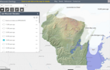
This arc GIS application interactive layer shows the stages of glacial ice locations across Wisconsin from 32,000 to 11,000 years before present. Shows subsequent impacts of glacial activity to form moraines, eskers, kames, and other glacial features including glacial melting to form glacial lakes and features across Wisconsin.
- Subject:
- Agriculture, Food and Natural Resources
- Career and Technical Education
- Earth and Space Science
- Geology
- Material Type:
- Activity/Lab
- Homework/Assignment
- Author:
- Jeff Dumez
- Date Added:
- 03/12/2024