5th Grade Rain Garden Design Challenge Handouts
Rain Garden Location & Design Challenge!
Group Members: ___________________________________________________________________________________
Using field investigation data and what you have learned from the in-class “Get Ready to Engineer: Rainwater Runoff Design Challenge,” your team will measure and use the data below to propose a site for a rain garden on school forest property.
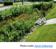
Step 1: Identify areas of runoff/erosion
From the designated starting location, conduct a survey of the school forest property within the boundaries indicated on your school forest property map by your instructor. Draw a circle on your map indicating any areas that show three or more indications of erosion and/or runoff within the designated area. Use the checklist below to guide you in circling areas showing high evidence of erosion and/or runoff:
Signs of erosion: Signs of runoff:
☐ Tree roots, small stones, or rocks exposed ☐ Flowing water on soil surface (after a rain)
☐ Gullies (wash-out ditches) visible ☐ Water collecting on soil surface (after a rain)
☐ Steam channels on land ☐ Sediment collecting on low areas or pavement
☐ Wood chips or other trail covering moved by flowing water
Step 2: Identify potential rain garden locations-Slope
With your team, choose 2-3 potential rain garden locations based on evidence of erosion and runoff criteria above. Follow the instructions and diagram below to fill in Table 1. Number each site in the table and indicate measurements and slope calculation. If the slope is greater than 12%, the site is not suitable for a rain garden.
Slope Measurement
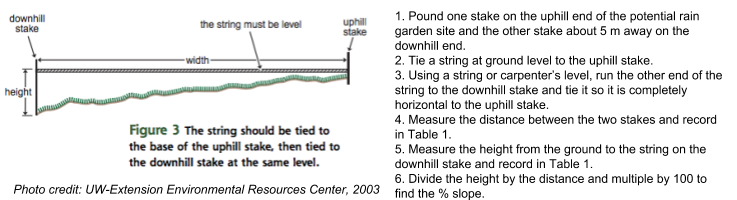
Table 1: Slope Measurements of Potential Rain Garden Site Locations
| Potential Rain Garden Site # | Distance (cm) | Height (cm) | % Slope (Height x 100) Distance | Greater than 12%? (Y/N) |
| 1 | ||||
| 2 | ||||
| 3 |
Step 3: Identify potential rain garden locations-Soil Type
Select the potential rain garden sites from Table 1 that fit the slope criteria (<12% slope). Next you will determine suitability based on soil type. Follow the directions below and record data in Table 2.
- Use a soil corer or hand trowel and a measuring tape or meter stick to dig 12-15 cm below the surface of the soil.
- Collect 3 soil samples of 2 tsp each from 12-15 cm depth and place in the palm of your hand.
- Add drops of water from your squeeze bottle until the soil is moldable, like putty.
- Knead the soil until it forms a ball. If it does not stay in a ball, record this in Table 2.
- If the soil forms a ball, use your thumb and pointer finger to roll the ball into a ribbon of soil of the same thickness and width. Keep rolling the ribbon until it breaks under its own weight. Record the data for when the ribbon breaks in Table 2. If the soil ribbon is greater than 5 cm before it breaks, it is not suitable for a rain garden.
Table 2: Soil Types of Potential Rain Garden Site Locations
| Potential Rain Garden Site # | Soil forms a ball? (Y/N) N=Sandy | Soil ribbon breaks at<2.5 cm (Y/N)Y = Silty | Soil ribbon breaks between 2.5-5 cm (Y/N)Y = Clayey | Soil ribbon breaks at > 5 cm (Y/N)Y = not suitable | Soil Type (Sandy, Silty, Clayey) | |
| 1 | 1 | |||||
| 2 | ||||||
| 3 | ||||||
| 2 | 1 | |||||
| 2 | ||||||
| 3 | ||||||
| 3 | 1 | |||||
| 2 | ||||||
| 3 | ||||||
Non-point Source Pollution: Phosphate
Group Members: ____________________________________________________________________________
Using field investigation data and what you have learned from the in-class “Get Ready to Engineer: Rainwater Runoff Design Challenge,” your team will measure the amount of phosphate in waterways at the school forest property. For both waterways, follow the procedure below and record data in Table 3.
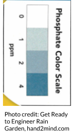
Step 4: Measure phosphate levels in waterways:
For each waterway, follow the procedure below to measure the amount of phosphate. Measure and test three water samples at each site and calculate the average of the three samples.
- Measure 5 mL of sample water into three 10 mL graduated cylinders with caps. (If using test tubes with stoppers, measure 5 mL of sample water into 3 test tubes.)
- Add 1 phosphate TesTab into each graduated cylinder or test tube.
- Cap the sample container and shake until the TesTab is completely dissolved.
- Using the stopwatch, measure 5 minutes of time.
- Compare the graduated cylinder or test tube to the Freshwater Phosphate Color Card to determine the ppm of phosphate in each water sample. Record in Table 3 below.
- Use a calculator to determine the average ppm phosphate in each waterway.
Table 3: Phosphate Levels in Field Study Site Waterways
| Waterway | Sample #1 | Sample #2 | Sample #3 | Average (ppm) |
| Pond | ||||
| Creek |

Rain Garden Design Challenge Criteria
Using field investigation data and what you have learned from the in-class “Get Ready to Engineer: Rainwater Runoff Design Challenge,” your team must a proposal for the location and design of your rain garden.
- The location proposal will be in the form of a CER and must meet the Location (Siting) criteria listed below.
- A map of the landscape, showing the proposed rain garden location and the direction of water flow, must be included.
- The design proposal will be in the form of a 2-dimensional rain garden model on graph paper that meets the Size, Shape, and Functionality criteria below.
Both the CER and rain garden model will be presented in a poster presentation format. Your proposal will be evaluated by other student groups (and you will evaluate other student group’s proposals). You will have the opportunity to revise your proposal based on student suggestions before your final instructor evaluation.
Location (Siting) criteria:
- Slope 12% or less
- Not over any septic system
- Not in any area that “ponds” regularly (stays wet after a rain)
- At least 10 ft (3 m) from any built structure
- Not directly under any large tree
- Not on any existing trail
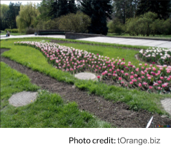
Size and Shape criteria:
- 100-300 sq. ft. (9-28 m2)
- 3-8 in. deep (8-20 cm)
-
At least twice as long as wide
- Length of rain garden perpendicular to landscape slope
- Crescent, kidney, or teardrop shape
Functionality criteria:
- Depth compensates for slope (see Table 4)
- Size factor compensates for soil type (see Table 5)
-
Rain garden utilizes prior “Reflect On It” results from in-class investigations
Table 4 (Reference): Rain Garden Depth vs. Slope
| Slope | Minimum Rain Garden Depth (cm) | Maximum Rain Garden Depth (cm) |
| < 4% | 8 | 13 |
| 5-7% | 16 | 18 |
| 8-12% | 20 | 20 |
| > 12% | Rain garden not recommended | |
Table 5 (Reference): Rain Garden Size Factor Based on Soil Type
| Rain Garden Depth (cm) | ||
| Soil Type | 7-12 | 12-20 |
| Sandy | 0.2 | 0.12 |
| Silty | 0.34 | 0.20 |
| Clayey | 0.43 | 0.28 |
| Other | Rain garden not recommended | |
| Rain Garden Design Assessment Rubric | |||||
| Design Criteria | 3-Unsatisfactory | 6-Proficient | 10-Advanced | Score & Comments | |
| Required Elements |
|
|
| ||
| Size |
|
|
| ||
| Shape |
|
|
| ||
| Functionality |
|
|
| ||
CER Organizer
 CLAIM
|
 EVIDENCE
|
 REASONING
|
| CLAIM: A one sentence answer to your essential question: What is the best location and design for a rain garden at the school forest? |
EVIDENCE: Include quantitative (number) and qualitative (descriptive) data: | REASONING/JUSTIFICATION OF EVIDENCE: Explain how the evidence supports the claim. |
CER Scoring Rubric:
Claim (2 pts) | Evidence (4 pts) | Reasoning (4 pts) | |
0 | Does not state a claim, does not answer the essential question or is incomplete | Does not provide evidence | Does not provide reasoning statements |
2 | Makes an accurate and complete claim that answers the research question. | Evidence is inappropriate or incomplete evidence | Reasoning statements do not explain how the evidence supports the claim. Design criteria are not referenced. Guidelines are not followed. |
4 | Provides appropriate (quantitative, qualitative or both) and complete (all evidence is used) evidence. | Reasoning statements explain how the evidence supports the claim. Design criteria are referenced and guidelines are followed. |
Total: ______/10
Poster Evaluation Questioning/Feedback Prompts:

- What data or evidence was most significant in helping to determine the best location for the rain garden?
- How does your rain garden design take into account the slope and soil type of the landscape?
- How were your “Reflect On It” results incorporated into your design?
- What challenges did you encounter in developing your proposal?
- How well did your team members work together? What were your strengths/weaknesses?
| Praise! | Suggestion for Improvement |