This activity is a classroom hands-on , active learning lesson where students …
This activity is a classroom hands-on , active learning lesson where students observe and describe a familiar item, to help them observe and describe the physical characteristics of rocks.
This simple puzzle game introduces kids to crystals! Players join the kids …
This simple puzzle game introduces kids to crystals! Players join the kids of the Yard and try their hand at arranging molecules with different shapes and properties into an ordered, stable configuration. Learn about crystals, repeating patterns, and molecular charges.
This site is a lecture by Dr. Stephen Nelson from Tulane University …
This site is a lecture by Dr. Stephen Nelson from Tulane University that explores the use of the Miller Index notation to designate crystal forms. Topics include crystal forms, general and special forms, and open and closed forms. Also discussed is the relationship between form and crystal faces, along with zones and zone symbols, the vectorial properties of crystals, and crystal habit. Tables and illustrations accompany the text.
This site is a lecture from Tulane University that explores the symmetry …
This site is a lecture from Tulane University that explores the symmetry observed in crystals. Topics covered include crystallographic axes, the crystal lattice, and unit cells. Tables and illustrations accompany the text.
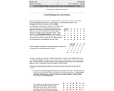
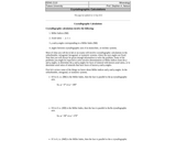
This site is a lecture by Dr. Stephen Nelson from Tulane University …
This site is a lecture by Dr. Stephen Nelson from Tulane University that discusses crystallographic calculations. Topics include a review of Miller indices, axial ratios, angles corresponding to a Miller Index, and angles between crystallographic axes in monoclinic or triclinic systems. Step by step examples of the calculations are provided, including associated illustrations and diagrams.
The leading source for current events, news and non-fictional content for Common …
The leading source for current events, news and non-fictional content for Common Core ELA, Science and Social Studies. With thousands of news articles and new original content added daily, we are the leading online source of current events for students, teachers and schools. Grades K-8
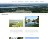
Dane County's abundant surface water resources are monitored and assessed primarily by …
Dane County's abundant surface water resources are monitored and assessed primarily by the Wisconsin Department of Natural Resources (WDNR). Major streams and lakes are classified into categories based on the aquatic organisms present. These classifications provide an indication of water quality and fishery conditions.
Agricultural and urban land uses contribute to nutrient rich runoff reaching surface waters. Impervious surfaces and removal of wetlands also increases the flow of stormwater to local waterways. Explore issues facing our surface water and see maps of degraded water resources.
Effective water quality planning depends on long-term assessment and monitoring. The Capital Area Regional Planning Commission uses long-term datasets to evaluate regional trends.
Learn about practices meant to protect the region's streams, shorelands, and lakes.
Dane County Land and Water Resources Viewer: An interactive county map showing watershed boundaries, thermally sensitive areas, cold water communities and more.
Density, Isostasy, and Topography Anne Egger, Stanford University The original activity Density, …
Density, Isostasy, and Topography Anne Egger, Stanford University The original activity Density, Isostasy, and Topography already exists within the SERC website. This page describes how this activity can be used ...
In this lesson, students learn how coal is used and mined, then …
In this lesson, students learn how coal is used and mined, then simulate the mining process and its impacts on the earth by attempting to remove chocolate chips from a cookie without destroying it. Includes a teacher guide and step-by-step instructions.
Students learn about the ancient carbon scyle and learn what the role …
Students learn about the ancient carbon scyle and learn what the role of dionsaurs was and then extent their knowledge to the concepts of global warming and how scientists are applying the carbon cycle to reduce harful CO2 emissions.
This is an investigation where students observe what happens to land after …
This is an investigation where students observe what happens to land after it is mined. Students will create a hypothesis, observe their model, conclude what happens to land after it is mined, and discover the role humans play in land conservation.
This activity asks students to use sports balls as scale models of …
This activity asks students to use sports balls as scale models of the Earth and the Moon. Students will determine the scale of the model system and the distance that must separate the two models.
Student teams commit to a final decision on the location they recommend …
Student teams commit to a final decision on the location they recommend for safe underground cavern shelter for the citizens of Alabraska. They prepare and deliver final presentations to defend their final decisions to the class.
This is a classroom activity in which students develop understanding of the …
This is a classroom activity in which students develop understanding of the rock cycle using wax crayons to model the processes that form the 3 types of rock; sedimentary, igneous & metamorphic.
EARTH 530 will introduce you to the basic information necessary for understanding …
EARTH 530 will introduce you to the basic information necessary for understanding Earth surface processes in the Critical Zone through an integration of various scientific disciplines. Those who successfully complete EARTH 530 will be able to apply their knowledge of fundamental concepts of Earth surface processes to understanding outstanding fundamental questions in Critical Zone science and how their lives are intimately linked to Critical Zone health.
The purpose of this lesson is to introduce students to the basic …
The purpose of this lesson is to introduce students to the basic elements of our Earth's crust: rocks, soils and minerals. They learn how we categorize rocks, soils and minerals and how they are literally the foundation for our civilization. Students also explore how engineers use rocks, soils and minerals to create the buildings, roads, vehicles, electronics, chemicals, and other objects we use to enhance our lives.
Our planet is becoming hot. In fact, Earth may be warming faster …
Our planet is becoming hot. In fact, Earth may be warming faster than ever before. This warming will challenge society throughout the 21st century. How do we cope with rising seas? How will we prepare for more intense hurricanes? How will we adapt to debilitating droughts and heat waves? Scientists are striving to improve predictions of how the environment will change and how it will impact humans. Earth in the Future: Predicting Climate Change and Its Impacts Over the Next Century is designed to provide the state of the art of climate science, the impact of warming on humans, as well as ways we can adapt. Every student will understand the challenges and opportunities of living in the 21st century.
The earthquake game teaches how scientists learn about real earthquakes. The player …
The earthquake game teaches how scientists learn about real earthquakes. The player must learn about S& P waves and triangulation to determine the epicenter of the earthquake that hit the cities.
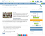
Students learn about the structure of the earth and how an earthquake …
Students learn about the structure of the earth and how an earthquake happens. In one activity, students make a model of the earth including all of its layers. In a teacher-led demonstration, students learn about continental drift. In another activity, students create models demonstrating the different types of faults.
No restrictions on your remixing, redistributing, or making derivative works. Give credit to the author, as required.
Your remixing, redistributing, or making derivatives works comes with some restrictions, including how it is shared.
Your redistributing comes with some restrictions. Do not remix or make derivative works.
Most restrictive license type. Prohibits most uses, sharing, and any changes.
Copyrighted materials, available under Fair Use and the TEACH Act for US-based educators, or other custom arrangements. Go to the resource provider to see their individual restrictions.